Research Article | | Peer-Reviewed

Inferences About Geographical Awareness and Map Representations in Early Japan

Received: 9 February 2026     Accepted: 24 February 2026     Published: 5 March 2026
Views:       Downloads:
Abstract

The methods by which territorial extent was understood in early Japan, spanning from the Yayoi period (third century BC–third century AD) to the Kofun period (third–seventh century AD) remain largely unknown. Nevertheless, it is likely that a certain level of geographical knowledge was necessary for interregional negotiation and the subsequent processes of political consolidation. Spatial patterns can be observed in the distribution of archaeological sites and prominent mountains. For example, when major ruins in the former Izumo Province, where numerous bronze artifacts have been excavated, are geographically linked with peaks such as Mt. Daisen and Mt. Sanbe, emerges as an approximately large-scale isosceles triangular configuration. Similarly, connecting Mt. Fuji, Mt. Daisen, and Mt. Takachiho—three of Japan’s most distinctive landmarks—also produces an enormous triangular arrangement. These triangular groupings are further associated with shared mythological traditions, which may suggest that a broad geographical awareness existed during this early period. Although definitive conclusions cannot yet be drawn from surviving records or material evidence, this study presents the relative spatial relationships among key mountains and archaeological sites. In addition, as an exploratory reconstruction, the Japanese archipelago is represented using a stick chart (branch-type map), a primitive cartographic form in order to examine possible modes of early geographical perception.

Published in American Journal of Civil Engineering (Volume 14, Issue 2)
DOI 10.11648/j.ajce.20261402.11
Page(s) 46-55
Creative Commons

This is an Open Access article, distributed under the terms of the Creative Commons Attribution 4.0 International License (http://creativecommons.org/licenses/by/4.0/), which permits unrestricted use, distribution and reproduction in any medium or format, provided the original work is properly cited.

Copyright

Copyright © The Author(s), 2026. Published by Science Publishing Group

Keywords

Ancient Geography, Archaeological Sites, Landmark Mountains, Spatial Alignment, Isosceles Triangle Patterns, Mythological Traditions, Stick Chart Mapping

1. Introduction
Even in early Japan, spanning from the Yayoi period (conventionally dated from the third century BC to the third century AD) through the Kofun period (third to seventh century AD), some form of wide-area surveying and mapping likely existed to support an understanding of the country’s geography. Such geographical knowledge would have been essential for coordinated social, political, and economic activities during these periods.
At the same time, notable spatial patterns can be observed in the distribution of archaeological sites and prominent mountains. For example, when major ruins in the former Izumo Province, where numerous bronze artifacts have been excavated, are geographically linked with peaks such as Mt. Daisen and Mt. Sanbe, approximate isosceles triangular configurations emerge. Moreover, connecting Mt. Fuji, Mt. Daisen, and Mt. Takachiho—three of Japan’s most distinctive landmarks—also produces an enormous triangular arrangement. These groupings are further associated with shared mythological traditions, which may suggest that a broad geographical awareness existed in early Japan.
However, at present, it remains difficult to draw definitive conclusions based solely on surviving historical records or material artifacts.
As a preliminary step toward examining geographical knowledge and possible surveying methods during this period, this study presents the spatial relationships among key mountains and archaeological sites and proposes an exploratory reconstruction of a map that may reflect contemporary geographical perceptions.
2. Literature Review
This section reviews existing studies and historical materials related to wide-area surveying and geographical understanding from the Yayoi period through the Kofun period.
The Pre-Meiji Civil Engineering History reports that primitive surveying practices existed in early Japan, with measurement units based on the human body, such as the span of outstretched arms, the length between finger joints, thumb width, upper-arm length, and leg length . However, the source does not provide about wide-area surveying methods or the production of maps.
Takeda Michiharu summarizes the historical development of surveying technology from ancient times to the present. According to his account, the world’s oldest known map was drawn on papyrus in ancient Egypt around 1330 BC. By approximately 600 BC, the Greek philosopher Thales is said to have applied a technique comparable to modern forward intersection. In China, one of the earliest surviving maps dates to around 150 BC in Changsha. In Japan, the oldest recorded national map is the Gyōki map, compiled in 743, although the original no longer exists. Modern triangulation was later developed in 1617 by the Dutch scientist Snellius. Takeda further argues that while surveying techniques may have existed since antiquity, direct cartographic evidence is often lacking. Instead, the presence of such techniques can sometimes be inferred from the geometric accuracy, orientation, and spatial arrangement of ancient monumental structures, such as pyramids, as well as from the relative positioning of constructed sites .
In the context of Japan, Kimura Toshiaki and Sumata Takanobu suggest that advanced civil engineering knowledge and surveying capabilities would have been required for the construction of large-scale Kofun tumuli .
Takebe Kenichi notes that ancient civil engineering technology has received relatively limited attention within the broader historiography of Japanese civil engineering .
Overall, although several studies imply the existence of early surveying knowledge, few provide concrete evidence of wide-area geographical representation or mapping practices during the Yayoi–Kofun periods. This gap motivates the present study.
3. Burial Sites of Bronze Artifacts in the Izumo Region
A large number of bronze artifacts have been excavated in the former Izumo Province (eastern Shimane Prefecture). In 1973, three bronze bells and six bronze swords were recovered from the Shidanioku site. Between 1984 and 1985, excavations at the Kojindani site yielded 358 bronze swords, 16 bronze spears, and six bronze bells. In 1996, a further 39 bronze bells were discovered at the Kamoiwakura site.
Although the precise function of these bronze objects and the reasons for their deposition remain uncertain, they are generally believed to have been associated with agricultural rituals and deposited in the first century AD .
Table 1 summarizes the major archaeological sites in Japan where large numbers of bronze artifacts have been unearthed. As shown in the table, only a limited number of sites nationwide have produced such concentrated assemblages. In particular, Kojindani represents the largest known discovery of bronze swords, while Kamoiwakura contains the largest assemblage of bronze bells.
Figure 1. Bronze artifacts found at the Shidanioku site. (after ).
Table 1. Major archaeological sites in Japan where large numbers of bronze artifacts have been unearthed.

Site Name

Prefecture

bronze swords

bronze socketed spearheads

Bronze dagger-axes

bronze bells

Yanagisawa

Nagano

8

6

Oiwayama

Shiga

24

Sakuragaoka

Hyogo

7

14

Kojindani

Shimane (former Izumo Province)

358

16

6

Kamoiwakura

39

Shidanioku

6

3

Hoshigochi

Tokushima

7

Gabaishiyama

Kagawa

5

1

Haramachi

Fukuoka

49

Momijigaoka

27

Antokuharada

12

Note: The sites listed were selected by the author based on References , and related sources.
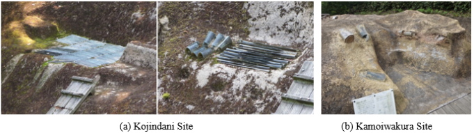
Figure 2. Restored remains and bronze artifacts at the Kojindani and Kamoiwakura sites.
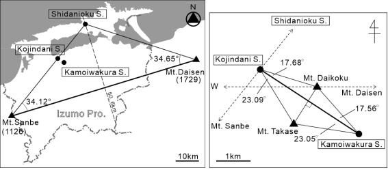
Figure 3. Locations of the bronze-artifact deposition sites and surrounding mountain landmarks.
Table 2. Geographic coordinates of mountain landmarks and bronze-artifact deposition sites.

Elevation (m)

Latitude (° ′ ″)

Longitude (° ′ ″)

Sources

Mt. Daisen

1,729

35°22′16″

133°32′46″

a

Mt. Sanbe

1,126

35°08′26″

132°37′18″

a

Mt. Daikoku

315

35°22′20″

132°52′16″

b

Mt. Takase

314

35°21′46″

132°51′49″

b

Shidanioku Site

35°31′02.0″

132°59′28.8″

c

Kojindani Site

35°22′35.3″

132°51′08.9″

c

Kamoiwakura Site

35°21′35.5″

132°53′00.3″

c

Notes:
a) Mountain data from the Geospatial Information Authority of Japan .
b) Coordinates measured from topographic maps.
c) Archaeological Database of Shimane Prefecture .
Table 3. Distances and azimuths between pairs of points.

Positional relationship

Distance (km)

Azimuth (°)

1)

Mt. Daisen – Mt. Sanbe

87.93

253.355194

2)

Mt. Daisen – Shidanioku Site

52.91

288.009111

3)

Mt. Sanbe – Mt. Daisen

87.93

72.821569

4)

Mt. Sanbe – Shidanioku Site

53.63

38.702153

5)

Shidanioku Site – Mt. Daisen

52.91

107.679189

6)

Shidanioku Site – Mt Sanbe

53.63

218.915919

7)

Mt. Daikoku – Mt. Takase

1.25

213.044978

8)

Mt. Daikoku – Kojindani Site

1.76

285.562400

9)

Mt. Daikoku – Kamoiwakura Site

1.77

140.801114

10)

Mt. Takase – Mt. Daikoku

1.25

33.040636

11)

Mt. Takase – Kojindani Site

1.83

326.330214

12)

Mt. Takase – Kamoiwakura Site

1.83

100.185625

13)

Kojindani Site – Mt. Daikoku

1.76

105.551611

14)

Kojindani Site – Mt. Takase

1.83

146.323767

15)

Kojindani Site – Kamoiwakura Site

3.36

123.230094

16)

Kamoiwakura Site – Mt. Daikoku

1.77

320.808236

17)

Kamoiwakura Site – Mt. Takase

1.83

280.197086

18)

Kamoiwakura Site – Kojindani Site

3.36

303.248006

Note: Distances and azimuths were obtained from the online computation service provided by the Geospatial Information Authority of Japan .
Table 4. Angles formed by triplets of points.

Point triplet (A–B–C)

Calculation*

Angle (°)

Remarks

Shidanioku Site – Mt. Daisen – Mt. Sanbe

2) – 1)

34.65

Equal base angle

Shidanioku Site – Mt. Sanbe – Mt. Daisen

3) – 4)

34.12

Mt. Daisen – Shidanioku Site – Mt. Sanbe

6) – 5)

111.24

Angle sum ≈ 180°

Intersection of Kojindani Site – Kamoiwakura Site line and Mt. Daikoku – Mt. Takase line

7) – 15)

89.81

Approximately right angle

Mt. Daikoku – Kojindani Site – Kamoiwakura Site

15) – 13)

17.68

Equal base angle

Mt. Daikoku – Kamoiwakura Site – Kojindani Site

16) – 18)

17.56

Kojindani Site – Mt. Daikoku – Kamoiwakura Site

8) – 9)

144.76

Angle sum = 180.0°

Mt. Takase – Kojindani Site – Kamoiwakura Site

14) – 15)

23.09

Equal base angle

Mt. Takase – Kamoiwakura Site – Kojindani Site

18) – 17)

23.05

Kojindani Site – Mt. Takase – Kamoiwakura Site

360° − 11) + 12)

133.86

Angle sum = 180.0°

* Calculation refers to the azimuth values listed in Table 3.
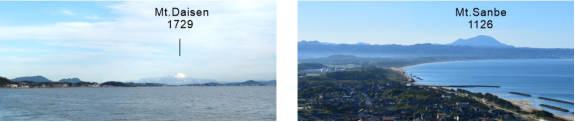
Figure 4. Mt. Daisen and Mt. Sanbe.
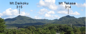
Figure 5. Mt. Daikoku and Mt. Takase.
The focus of this paper is motivated by the geometric relationship observed among the archaeological sites and surrounding landmarks. As illustrated in Figure 3, the three bronze-artifact deposition sites—Shidanioku, Kojindani, and Kamoiwakura—and the four prominent local landmarks—Mt. Daisen, Mt. Sanbe, Mt. Daikoku, and Mt. Takase—collectively define three isosceles triangles.
Table 2 summarizes the geographic coordinates of each location. Table 3 presents the azimuth directions between pairs of points, while Table 4 provides the angles formed by triplets of points (the same analytical procedure is applied in Tables 6, 7, 8).
As shown in Figures 4 and 5, Mt. Daisen and Mt. Sanbe, as well as Mt. Daikoku and Mt. Takase, can be interpreted as paired landmarks within the regional topographic setting. However, it should be noted that direct intervisibility does not exist between the mountains and the archaeological sites, nor among the sites themselves, due to intervening terrain conditions .
Table 5 evaluates the likelihood that the observed site locations satisfy the geometric conditions required to form isosceles triangles. It should be noted that these represent evaluations of certain events. Although the quantities employed in this analysis are commonly treated as geometric deviations or tolerances, they are interpreted here as normalized measures indicating how closely the spatial configuration conforms to an ideal isosceles-triangle geometry.
The Shidanioku Site was evaluated using the ratio between the area calculated from twice the offset distance from the perpendicular bisector of the Mt. Daisen–Mt. Sanbe baseline and its length (Figure 3: 50.6 km)—that is, the range within which an isosceles triangle is considered to be formed—and the total area.
p1=44.22km2/2785.28km2≈1/60.
The configuration involving Kojindani Site, Kamoiwakura Site, Mt. Daikoku, and Mt. Takase were assessed using the following two criteria:
a) The deviation of the intersection angle between the Mt. Daikoku–Mt. Takase line and the Kojindani–Kamoiwakura line from a right angle (90°). This yields,
p21=0.19°/90°<1/100.
b) The offset distance of Mt. Daikoku, which constitutes the vertex of the isosceles triangle, from the perpendicular bisector of the Kojindani–Kamoiwakura baseline. The corresponding index is.
p22= 0.003km/ 3.36km<1/100.
If the locations of the bronze-artifact deposition sites had been selected without regard to geometric considerations, the formation of these isosceles-triangle relationships would be unlikely. Even allowing for uncertainties associated with map-based identification of mountain summits, the observed geometric regularity suggests that deliberate spatial considerations may have influenced the selection of these sites.
It should be noted, however, that the locations inferred from the above calculations do not uniquely determine the actual positions of the sites. Multiple candidate points exist along perpendicular bisectors and related geometric loci. In practice, additional factors—such as directional alignment and relationships with sacred mountains—are also likely to have played an important role in site selection .
Table 5. Normalized indices evaluating the geometric likelihood of site locations.

Base (km, km2, °)

Angle (°)

Hypotenuse (km)

Projection (km)

BL/2 (km)

Difference (km, km2, °)

Probability

Symbols

BL: Mt. Daisen – Mt. Sanbe, ∠Shidanioku – Mt. Daisen – Mt. Sanbe

87.93km

34.65

52.91

43.528

43.965

0.437km

≈1/60

p1

2782.28km2

0.437km x 2 x 50.6km =

44.22km2

Intersection angle, Mt. Daikoku – Mt. Takase ⊥ Kojindani – Kamoiwakura

90°

89.81

0.19°

<1/100

p21

BL: Kojindani – Kamoiwakura, ∠Mt. Takase – Kojindani – Kaomoiwakura

3.36km

17.68

1.76

1.677

1.680

0.003km

<1/100

p22

Notes:
Area of Izumo Province: Matsue City, 572.96 km²; Izumo City, 624.32 km²; Yasugi City, 420.93 km²; Unnan City, 553.18 km²; Okuizumo Town, 368.01 km²; Iinan Town, 242.88 km²; total 2,782.28 km² (as of October 1, 2025).
Although the area was not identical in ancient times, there is no substantial difference from the present extent.
p2=p21 x p22< 1/10,000.
p=p1 x p2<1/600,000.
4. Mt. Fuji – Mt. Daisen – Mt. Takachiho
In this section, we examine mountains exhibiting distinct spatial relationships, focusing on areas of interaction in ancient Japan from the Yayoi through the Kofun period.
As indicated in Figure 6 and summarized in Tables 6, 7, and 8, Mt. Fuji, Mt. Daisen, and Mt. Takachiho define a large-scale isosceles triangle, with base angles of approximately 27.4° and 28.3°. Notably, Mt. Daisen is situated almost due west of Mt. Fuji. Furthermore, the line connecting Mt. Fuji and Mt. Takachiho is approximately aligned with the azimuths of sunrise and sunset at the summer and winter solstices in this region.
The resulting configuration is also close to a 30°–120°–30° triangle, which represents a geometrically simple and potentially repeatable form.
As shown in Figure 7, Mt. Fuji, Mt. Daisen, and Mt. Takachiho constitute prominent landmarks that are visible over long distances. This spatial relationship may provide useful insight into how large-scale geography could have been recognized in ancient Japan.
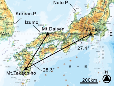
Figure 6. Location of the three mountains considered in this analysis.
5. Relationship with Myths and Legends
Mt. Daisen and Mt. Sanbe, which constitute prominent landmarks in the former Izumo Province, appear in the well-known “Myth of Land Pulling” (Kunibiki Shinwa), recorded in the Izumo-no-kuni Fudoki (733).
Table 6. Geographic coordinates of Mt. Fuji, Mt. Daisen, and Mt. Takachiho, and associated enshrined deities.

Elevation (m)

Latitude (° ′ ″)

Longitude (° ′ ″)

Latitude difference (° ′ ″)

Source

Enshrined deity

Mt. Fuji

3776

35°21′39″

138°43′39″

a

Konohana

Mt. Daisen

1729

35°22′16″

133°32′46″

0°00′37″

a

Okuninushi

Mt. Takachiho

1574

31°53′11″

130°55′08″

a

Ninigi

Note: a) Mountain data from the Geospatial Information Authority of Japan .
Table 7. Distances and azimuths between mountain pairs.

Positional relationship

Distance (km)

Azimuth (°)

1)

Mt. Fuji – Mt. Daisen

470.83

271.638822

2)

Mt. Fuji – Mt. Takatiho

820.29

244.198742

3)

Mt. Daisen – Mt. Fuji

470.83

88.638483

4)

Mt. Daisen – Mt. Takaciho

456.91

212.975322

5)

Mt. Takachiho – Mt. Fuji

820.29

59.868181

6)

Mt. Takachiho – Mt. Daisen

456.91

31.519489

Note: Distances and azimuths were obtained from the online computation service provided by the Geospatial Information Authority of Japan .
Table 8. Angles formed by the Mt. Fuji–Mt. Daisen–Mt. Takachiho.

Positional relationship

Calculation

Angle (°)

Remarks

Mt. Daisen – Mt. Fuji – Mt. Takachiho

1) − 2)

27.4

Equal base angle

Mt. Daisen – Mt. Takachiho – Mt. Fuji

5) − 6)

28.3

Mt. Fuji – Mt. Daisen – Mt. Takachiho

4) − 3)

124.3

Angle sum = 180.0°

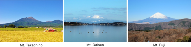
Figure 7. Mt. Fuji, Mt. Daisen, and Mt. Takachiho (Mt. Takachiho image courtesy of Miyazaki Tourism Navi).
According to the Izumo-no-kuni Fudoki, the newly established land of Izumo was described as being geographically small. The deity Yatsukamizu-omizunu-no-mikoto is said to have expanded the region by “pulling” surplus lands from several distant areas, including the Korean Peninsula and the Noto Peninsula, and anchoring them using Mt. Daisen and Mt. Sanbe as stakes.
In addition, the spatial relationship among Mt. Fuji, Mt. Daisen, and Mt. Takachiho is associated with major deities in Japanese mythology. Konohana-sakuya-hime is enshrined at Mt. Fuji, Okuninushi-no-mikoto at Mt. Daisen, and Mt. Takachiho is traditionally regarded as the site of Ninigi-no-mikoto’s descent. In the narratives recorded in the Kojiki (712) and the Nihon Shoki (720), Okuninushi is described as transferring authority to the heavenly lineage (Takamagahara), after which Ninigi descends to earth. Konohana is identified as Ninigi’s consort. These figures are therefore connected through the so-called “Myth of the Transfer of the Land.”
Based on these traditions, it may be suggested that ancient communities possessed an awareness of large-scale geographic relationships among prominent landmarks.
Although Japanese mythological accounts are interpreted as reflecting aspects of the Yayoi period, particularly through references to rice cultivation, substantial uncertainties remain regarding their chronology and historical context. The timing of the enshrinement of these deities at specific mountains is also unclear, and spatial relationships alone are insufficient to identify the motivations or surveying methods underlying the selection of these locations.
In the following section, one possible hypothesis concerning the conceptual “map” of ancient Japan is proposed.
6. Stick Charts (Branch-type Maps)
According to the Japan Hydrographic Association, a type of nautical chart known as a “stick chart” (branch-type map) was historically used in the Marshall Islands of Micronesia from the nineteenth to the early twentieth century. These charts were constructed by fastening perforated pebbles and shells to palm-leaf stalks. The pebbles and shells represented islands and atolls, whereas the palm-leaf framework indicated the directions of ocean currents and swells .
As shown in Figure 8, stick charts provide a simplified yet functional representation of spatial relationships, conveying both directional information and relative location. Despite their minimal structure, they incorporate the essential elements required for regional navigation and may be regarded as an early form of large-scale spatial mapping.
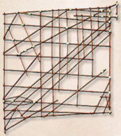
Figure 8. Example of a stick chart.
Figure 9 presents an attempt to represent the main islands of Japan, together with several smaller islands, using a stick-chart framework.
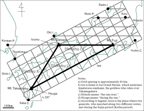
Figure 9. Conceptual stick-chart representation of the Japanese archipelago based on the Mt. Fuji–Mt. Daisen–Mt. Takachiho geometric framework.
The proposed concept is summarized as follows.
a) Mt. Fuji and Mt. Daisen define the principal east–west reference axis.
b) Mt. Fuji, Mt. Daisen, and Mt. Takachiho form an enormous isosceles triangle, approximately corresponding to a 30°–120°–30° geometry.
c) By introducing lines parallel and perpendicular to this large triangle, the principal region of interaction in ancient Japan can be approximately enclosed.
d) Additional auxiliary lines, spaced at intervals of about 80 km, can be superimposed to generate a grid system, enabling the relative positioning of individual locations.
e) Although the grid in Figure 9 is not strictly uniform, this is not a major limitation, since its primary purpose is to provide approximate locations of non-visible areas through visual interpolation.
f) The resulting grid framework may function as a practical map when supplemented with key points and travel routes.
g) The lattice structure could be constructed using straight bamboo rods or similar materials.
h) A stick chart of approximately 1–2 m in length, corresponding to a scale of roughly 1:1,000,000 to 1:500,000, would be suitable for practical use.
7. Conclusion
Even in the early history of Japan, from the Yayoi period (third century BC–third century AD) through the Kofun period (third–seventh century AD), it is unlikely that political negotiation and regional power formation could have occurred without a reasonably accurate understanding of geographic space.
This study has identified clear spatial relationships between three major bronze-artifact burial sites in the Izumo region and prominent local landmarks, including Mt. Daisen and Mt. Sanbe. In addition, Mt. Fuji, Mt. Daisen, and Mt. Takachiho form a large-scale geometric configuration that is also associated with interconnected myths and traditions.
By constructing parallel and perpendicular reference lines from this core isosceles triangle, it becomes possible to conceptually encompass the elongated Japanese archipelago, extending from southern Kyushu to Sado Island. When auxiliary lines are added at regular intervals, a grid-like framework resembling a stick chart can be obtained.
Although this paper does not provide direct evidence of ancient surveying techniques or wide-area maps, it aims to draw attention to spatial correspondences that are difficult to dismiss as mere coincidence. It further encourages interdisciplinary interpretation of these relationships, including perspectives from civil engineering, archaeology, and historical geography.
However, no archaeological artifacts currently support the stick-chart hypothesis. Prior spatial knowledge may aid geographic cognition, surveying, and the interpretation of archaeological finds, and related activities. The proposed framework is offered as one possible interpretive model.
It is expected that these issues will be clarified further through future research.
Abbreviations

Konohana

Konohana-sakuya-hime

Okuninushi

Okuninushi-no-mikoto

Ninigi

Ninigi-no-mikoto

Author Contributions
Kaoru Yoshida: Writing – original draft
Conflicts of Interest
The author declares no conflicts of interest.
References
[1] Japan Society of Civil Engineers, “Pre-Meiji Civil Engineering History”, Iwanami Shoten, 1936, p. 1464.
[2] Takeda Michiharu, “Surveying from ancient times to the present”, Kokon Shoin, 1979, pp. 3-5, pp. 144-148, p. 155, pp. 248-250.
[3] Kimura Toshiaki, “Principles of ancient regional planning Part 1”, Collection of papers on the history of civil engineering research in Japan vol. 2, Japan Society of Civil Engineers, 1982, pp. 83-85.
[4] Sumata Takanobu, “Ancient Civil Engineering Techniques in the Placement of Ruins in the Kinki Region”, Civil Engineering History Research Vol. 10, Japan Society of Civil Engineers, 1990, p. 307.
[5] Takebe Kenichi, “Twenty Years of Historical Study on Civil Engineering in Japan”, Japan Society of Civil Engineers, 2000, p. 6.
[6] Shimane Prefectural Board of Education, Asahi Shimbun, “Ancient Izumo, An Exhibition of Eternal Heritage from the Land of the Gods”, 1997, p. 54, p. 56, p. 260.
[7] Shimane Prefectural Ancient Culture Center, “Bronze-artifacts Burial Sites Investigation Report 1, Bronze Bells”, Shimane Prefectural Board of Education, 2002, p. 24, p. 58, pp. 81-82, pp. 92-93, p. 97.
[8] Shimane Prefectural Ancient Culture Center, “Bronze-artifacts Burial Sites Investigation Report 2, Weapon-shaped Bronze Artifacts”, Shimane Prefectural Board of Education, 2006, pp. 47-49.
[9] Kaoru Yoshida, “Traces of Ancient Surveying in Japan”, Transactions on Engineering and Computing Sciences, Services for Science and Education, United Kingdom, Vol. 12 No. 3, 2024, pp. 88-100,
[10] Geospatial Information Authority of Japan, “List of mountains”,
[11] Shimane University, “Archaeological Database of Shimane”,
[12] Japan Hydrographic Association, “A Nautical Stick Chart”,
Cite This Article
  • APA Style

    Yoshida, K. (2026). Inferences About Geographical Awareness and Map Representations in Early Japan. American Journal of Civil Engineering, 14(2), 46-55. https://doi.org/10.11648/j.ajce.20261402.11

    Copy | Download

    ACS Style

    Yoshida, K. Inferences About Geographical Awareness and Map Representations in Early Japan. Am. J. Civ. Eng. 2026, 14(2), 46-55. doi: 10.11648/j.ajce.20261402.11

    Copy | Download

    AMA Style

    Yoshida K. Inferences About Geographical Awareness and Map Representations in Early Japan. Am J Civ Eng. 2026;14(2):46-55. doi: 10.11648/j.ajce.20261402.11

    Copy | Download

  • @article{10.11648/j.ajce.20261402.11,
      author = {Kaoru Yoshida},
      title = {Inferences About Geographical Awareness and Map Representations in Early Japan},
      journal = {American Journal of Civil Engineering},
      volume = {14},
      number = {2},
      pages = {46-55},
      doi = {10.11648/j.ajce.20261402.11},
      url = {https://doi.org/10.11648/j.ajce.20261402.11},
      eprint = {https://article.sciencepublishinggroup.com/pdf/10.11648.j.ajce.20261402.11},
      abstract = {The methods by which territorial extent was understood in early Japan, spanning from the Yayoi period (third century BC–third century AD) to the Kofun period (third–seventh century AD) remain largely unknown. Nevertheless, it is likely that a certain level of geographical knowledge was necessary for interregional negotiation and the subsequent processes of political consolidation. Spatial patterns can be observed in the distribution of archaeological sites and prominent mountains. For example, when major ruins in the former Izumo Province, where numerous bronze artifacts have been excavated, are geographically linked with peaks such as Mt. Daisen and Mt. Sanbe, emerges as an approximately large-scale isosceles triangular configuration. Similarly, connecting Mt. Fuji, Mt. Daisen, and Mt. Takachiho—three of Japan’s most distinctive landmarks—also produces an enormous triangular arrangement. These triangular groupings are further associated with shared mythological traditions, which may suggest that a broad geographical awareness existed during this early period. Although definitive conclusions cannot yet be drawn from surviving records or material evidence, this study presents the relative spatial relationships among key mountains and archaeological sites. In addition, as an exploratory reconstruction, the Japanese archipelago is represented using a stick chart (branch-type map), a primitive cartographic form in order to examine possible modes of early geographical perception.},
     year = {2026}
    }
    

    Copy | Download

  • TY  - JOUR
    T1  - Inferences About Geographical Awareness and Map Representations in Early Japan
    AU  - Kaoru Yoshida
    Y1  - 2026/03/05
    PY  - 2026
    N1  - https://doi.org/10.11648/j.ajce.20261402.11
    DO  - 10.11648/j.ajce.20261402.11
    T2  - American Journal of Civil Engineering
    JF  - American Journal of Civil Engineering
    JO  - American Journal of Civil Engineering
    SP  - 46
    EP  - 55
    PB  - Science Publishing Group
    SN  - 2330-8737
    UR  - https://doi.org/10.11648/j.ajce.20261402.11
    AB  - The methods by which territorial extent was understood in early Japan, spanning from the Yayoi period (third century BC–third century AD) to the Kofun period (third–seventh century AD) remain largely unknown. Nevertheless, it is likely that a certain level of geographical knowledge was necessary for interregional negotiation and the subsequent processes of political consolidation. Spatial patterns can be observed in the distribution of archaeological sites and prominent mountains. For example, when major ruins in the former Izumo Province, where numerous bronze artifacts have been excavated, are geographically linked with peaks such as Mt. Daisen and Mt. Sanbe, emerges as an approximately large-scale isosceles triangular configuration. Similarly, connecting Mt. Fuji, Mt. Daisen, and Mt. Takachiho—three of Japan’s most distinctive landmarks—also produces an enormous triangular arrangement. These triangular groupings are further associated with shared mythological traditions, which may suggest that a broad geographical awareness existed during this early period. Although definitive conclusions cannot yet be drawn from surviving records or material evidence, this study presents the relative spatial relationships among key mountains and archaeological sites. In addition, as an exploratory reconstruction, the Japanese archipelago is represented using a stick chart (branch-type map), a primitive cartographic form in order to examine possible modes of early geographical perception.
    VL  - 14
    IS  - 2
    ER  - 

    Copy | Download

Author Information