Abstract
Traffic congestion is a major urban transportation challenge in Dhaka, particularly along key arterial routes. This study assesses traffic congestion along the Banglamotor–Malibagh route using traffic performance analysis and questionnaire-based surveys. Field observations indicate severely degraded operating conditions, with volume-to-capacity (V/C) ratios of 1.01 and 1.04 in the two directions, confirming that traffic demand exceeds available roadway capacity. The route operates at Level of Service (LOS) F, characterized by unstable flow, frequent interrupted flow conditions, and low average speeds of 13.30 mph and 13.23 mph in the respective directions. Traffic composition analysis reveals that rickshaws, motorcycles and buses are the predominant contributors to congestion. In addition, on-street parking and roadside activities reduce effective carriageway width by approximately 20%–60%, further constraining capacity. A structured questionnaire survey conducted among route users including drivers, pedestrians, traffic police, and passengers reveals that non-motorized vehicles, inadequate pedestrian safety and uncontrolled passenger pick-up and drop-off activities are major operational challenges. Major findings of the study highlight that congestion is not solely a capacity issue but is strongly influenced by unmanaged mixed traffic operations and roadside disruptions. The study emphasizes that without proper regulation and coordination, infrastructure improvements alone are insufficient to address congestion. To improve traffic conditions, the study recommends signal optimization, control of non-motorized and slow-moving vehicles, provision of designated stopping areas and strengthened traffic management and enforcement. An integrated and coordinated approach is essential to enhance mobility and ensure sustainable transport performance along the route.
Keywords
Traffic, Congestion, Volume to Capacity, Roadway Capacity, Level of Service, On-street Parking, Non-motorized Vehicle,
Traffic Management
1. Introduction
Traffic congestion has become a growing challenge in cities worldwide, negatively influencing daily life of people, economic efficiency and environmental sustainability. In Dhaka, the capital of Bangladesh, traffic congestion has become a major issue, disrupting residents’ daily activities and hindering overall urban development. Traffic congestion in Dhaka stems from multiple interrelated factors, such as insufficient public transportation, limited and poorly developed road infrastructure, rapid and largely unregulated growth of private vehicles and ineffective traffic management. As a result, the city’s roads are becoming severely congested, leaving vehicles trapped for long periods. This situation contributes to rising air pollution, creating serious health risks for residents. Moreover, traffic congestion imposes substantial economic losses through reduced productivity, excessive fuel consumption and higher transportation expenses.
| [1] | Ali, Y., Rafay, M., Khan, R. D. A., Sorn, M. K., Jiang, H. Traffic Problems in Dhaka City: Causes, Effects, and Solutions (Case Study to Develop a Business Model). Open Access Library Journal. 2023, 10, e9994.
https://doi.org/10.4236/oalib.1109994 |
[1]
The Malibagh to Bangla Motor route, a vital route within Dhaka's transportation network, has been particularly susceptible to severe traffic congestion due to its strategic importance, high population density and significant commercial activities.
This research aims to comprehensively analyze and understand the various factors contributing to the persistent traffic congestion along the Malibagh to Bangla Motor route by delving into the underlying causes of this congestion. The research endeavors to identify potential solutions and strategies that can alleviate the traffic-related challenges and pave the way for a more efficient and sustainable urban transportation system.
2. Background of the Study
Urbanization has brought about significant economic growth and social development, but it has also introduced a myriad of challenges, with traffic congestion being a prominent issue in many cities across the globe. Dhaka, the capital of Bangladesh, stands as a prime example of a rapidly growing urban center grappling with the adverse effects of unchecked urbanization, particularly evident in the persistent traffic congestion along major roadways.
Dhaka is one of the most densely populated cities in the world, and its transport infrastructure has not been able to keep pace with rapid urbanization and population growth, resulting in severe and persistent traffic congestion. Limited road capacity and inefficient traffic operations, along with increasing travel demand, frequently create gridlock across major routes and local streets.
| [1] | Ali, Y., Rafay, M., Khan, R. D. A., Sorn, M. K., Jiang, H. Traffic Problems in Dhaka City: Causes, Effects, and Solutions (Case Study to Develop a Business Model). Open Access Library Journal. 2023, 10, e9994.
https://doi.org/10.4236/oalib.1109994 |
| [2] | Haider, M. Z., Papri, R. S. Cost of Traffic Congestion in Dhaka Metropolitan City. Public Transport. 2021, 13, 287–299. https://doi.org/10.1007/s12469-021-00270-4 |
[1, 2]
The city’s heterogeneous traffic—where buses, private cars, motorcycles, three-wheelers, and slow-moving rickshaws share the same road space—reduces roadway efficiency and leads to frequent bottlenecks and delays.
| [1] | Ali, Y., Rafay, M., Khan, R. D. A., Sorn, M. K., Jiang, H. Traffic Problems in Dhaka City: Causes, Effects, and Solutions (Case Study to Develop a Business Model). Open Access Library Journal. 2023, 10, e9994.
https://doi.org/10.4236/oalib.1109994 |
[1]
The average traffic speed in Dhaka has fallen from 21 kmph to 7 kmph in the last 15 years.
| [5] | Abir, A. T. M., Rahman, M. M., Islam, F., Bashar, R., Islam, S. User Response–Based Sustainable Solutions to Traffic Congestion Problem Using Public Transport: The Case of Uttara, Dhaka. International Journal of Transportation Engineering and Technology. 2018, 4(2), 23–30.
https://doi.org/10.5923/j.ijtte.20180702.03 |
[5]
In addition, weaknesses in traffic governance and enforcement, such as illegal stopping, rule violations, and unregulated roadside activities, further worsen congestion.
| [1] | Ali, Y., Rafay, M., Khan, R. D. A., Sorn, M. K., Jiang, H. Traffic Problems in Dhaka City: Causes, Effects, and Solutions (Case Study to Develop a Business Model). Open Access Library Journal. 2023, 10, e9994.
https://doi.org/10.4236/oalib.1109994 |
| [3] | Islam, K. R., Yeasmin, K. M. Behavioral Aspects of Drivers as Contributing to Traffic Jam: The Case of Dhaka City’s Bus Drivers. The Chittagong University Journal of Social Sciences. 2025, 34, 1–16. |
[1, 3]
The consequences are significant: congestion causes major economic losses through wasted working hours, increased fuel consumption, and reduced productivity.
Moreover, prolonged exposure to congestion increases environmental and health risks due to higher vehicle emissions and longer travel times for daily commuters.
| [4] | Ali, M., Ahsan, G. U., Hossain, A. Traffic Congestion and Physical Health of Commuters: Perspective of Dhaka City. Journal of Contemporary Studies in Epidemiology and Public Health. 2021, 2. https://doi.org/10.30935/jconseph/9365 |
[4]
Although several initiatives such as mass rapid transit development and infrastructure expansion have been undertaken, research suggests that Dhaka requires integrated long-term strategies combining improved public transport, effective traffic management, and coordinated urban planning to achieve sustainable mobility.
| [1] | Ali, Y., Rafay, M., Khan, R. D. A., Sorn, M. K., Jiang, H. Traffic Problems in Dhaka City: Causes, Effects, and Solutions (Case Study to Develop a Business Model). Open Access Library Journal. 2023, 10, e9994.
https://doi.org/10.4236/oalib.1109994 |
| [3] | Islam, K. R., Yeasmin, K. M. Behavioral Aspects of Drivers as Contributing to Traffic Jam: The Case of Dhaka City’s Bus Drivers. The Chittagong University Journal of Social Sciences. 2025, 34, 1–16. |
[1, 3]
In these contexts evaluating the causes of traffic congestion in the major routes of the city will play a vital role for traffic management.
The Malibagh to Bangla Motor route, a crucial arterial road network within Dhaka, has witnessed an alarming escalation in traffic congestion over the years. This route traverses through densely populated neighborhoods, bustling commercial areas, and key transportation hubs, making it a lifeline for the city's daily activities and economic transactions. However, the route's significance has inadvertently contributed to its own predicament – an intricate web of congestion that disrupts both human mobility and economic vitality.
Previous studies on traffic congestion in Dhaka have largely focused on citywide patterns, policy-level interventions, or isolated traffic indicators, with limited attention to route-specific physical and operational constraints. This study presents a route-level traffic congestion assessment for a critical urban route in Dhaka using combined engineering surveys, AADT analysis, road-width occupancy, and user perception data. Unlike citywide or model-based studies, it integrates physical roadway constraints with on-site behavioral observations to identify location-specific congestion mechanisms. The findings provide actionable, low-cost traffic management insights for highly constrained road routes in developing cities. Accordingly, this study aims to evaluate traffic demand–capacity imbalance, roadside encroachments, and user-perceived congestion factors along the Malibagh–Bangla Motor route.
3. Literature Review
Traffic congestion in Dhaka has been widely recognized as a critical urban challenge resulting from rapid population growth, mixed traffic conditions, inadequate infrastructure, and inefficient traffic management. Several studies have examined the structural and operational causes of congestion in the city. For instance, Rahman and Hoque (2018) identified poor traffic management, insufficient road capacity, and weak enforcement of traffic regulations as key contributors to chronic congestion in Dhaka
| [9] | Salehin, M. S., Jubailee, T., Sourav, M. M. I., et al. A Structural Equation Modeling Approach to Understand Users’ Perceptions of App-Based CNG Auto-Rickshaw Services in Dhaka City. Journal of Engineering and Applied Science. 2024, 71, Article 45. https://doi.org/10.1186/s44147-024-00368-z |
[9].
Similarly, Sharmeen et al. (2012) developed a traffic impact assessment (TIA) methodology for mixed land-use developments in Dhaka, emphasizing the importance of systematic engineering surveys in evaluating traffic performance
These studies primarily rely on quantitative traffic measurements such as volume counts, roadway capacity, and intersection performance, highlighting the significance of engineering-based approaches in congestion assessment.
Beyond traditional engineering surveys, recent research underscores the importance of incorporating user perceptions into congestion analysis. Abir et al. (2018) investigated commuter responses to public transport conditions in Uttara, Dhaka, demonstrating that user dissatisfaction with service reliability and comfort influences travel mode choice and contributes indirectly to congestion
| [6] | Al-Qadery, S. M. A., Muhibbullah, M. People’s Perception on Urban Traffic Congestion: A Case Study on Chittagong Metropolitan City, Bangladesh. Chittagong University Journal of Biological Sciences. 2013, 8(1–2), 45–60.
https://doi.org/10.3329/cujbs.v3i1.13415 |
[6].
Likewise, Al-Qadery and Muhibbullah (2013), in their study of Chittagong Metropolitan City, showed that residents’ perceptions of congestion cause often differ from purely technical evaluations, suggesting that subjective assessments provide complementary insights into traffic problems
| [7] | Das, P., Debnath, B., Hoque, I., Islam, S. Assessing the Potential of Shared Mobility to Alleviate Traffic Congestion: A Traffic Survey and Simulation Study in Dhaka. Proceedings of ICERIE 2025. 2025. https://doi.org/10.2991/978-94-6463-884-4_20 |
[7].
These findings indicate that understanding behavioral and perceptual dimensions is essential for designing effective congestion mitigation strategies.
More advanced methodological frameworks have also been applied to integrate perception-based analysis with quantitative modeling. Salehin et al. (2024) employed Structural Equation Modeling (SEM) to analyze users’ perceptions of app-based CNG auto-rickshaw services in Dhaka, demonstrating how latent perception variables can be statistically linked to measurable transport performance indicators
| [10] | Sharmeen, N., Sadat, K., Zaman, N., Mitra, S. K. Developing a Generic Methodology for Traffic Impact Assessment of a Mixed Land Use in Dhaka City. Journal of Bangladesh Institute of Planners. 2012, 5, 55–66.
https://doi.org/10.3329/jbip.v5i1.77026 |
[10].
Similarly, Das et al. (2025) combined traffic survey data with simulation modeling to evaluate shared mobility interventions in Dhaka, illustrating the value of integrating field-based engineering data with user-oriented survey responses
These studies provide methodological support for combining objective traffic measurements with perception-based data within a unified analytical framework.
From a broader perspective, congestion assessment literature emphasizes the need for comprehensive evaluation approaches that incorporate both quantitative performance metrics and qualitative insights. Subair et al. (2024) reviewed urban congestion evaluation methods and concluded that multidimensional assessment frameworks produce more reliable policy recommendations than single-indicator approaches
| [12] | Parkavi, S. P., Angamuthu, P. Assessing Urban Traffic Congestion for Sustainable Transportation in Chennai, India. Frontiers in Sustainable Cities. 2025, 7, 1684489.
https://doi.org/10.3389/frsc.2025.1684489 |
[12].
Comparative studies in other Asian cities, such as the work of Sridhar Parkavi and Angamuthu (2025), further highlight the importance of intersection-level engineering analysis combined with contextual understanding of urban mobility behavior
| [13] | Jing, P., Huang, H., Chen, L. An Adaptive Traffic Signal Control in a Connected Vehicle Environment: A Systematic Review. Information. 2017, 8(3), 101.
https://doi.org/10.3390/info8030101 |
[13].
Thus, existing studies on traffic congestion primarily rely on aggregate engineering measures or perception-based analyses in isolation. However, limited research integrates both approaches at a corridor-specific operational level. This study addresses this gap by combining traffic performance evaluation with user perception analysis along a major arterial route in Dhaka. The novelty lies in capturing the joint effects of mixed traffic, roadside activities, and user-experienced issues within a unified framework.
4. Selection of Study Area
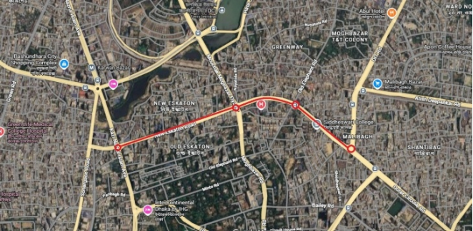
The Banglamotor–Malibagh route is one of the most important and highly congested road segments in Dhaka city due to its strategic role in connecting major commercial, residential, and institutional zones. This route experiences heavy traffic flow throughout the day, with congestion intensifying during peak hours because of high demand, limited road width, and frequent interruptions at intersections. The presence of mixed traffic such as buses, private cars, CNG auto-rickshaws, rickshaws, and motorcycles creates irregular movement patterns and reduces roadway efficiency. Since Malibagh Mor functions as a key junction connecting routes toward Rampura, Badda and central Dhaka. Even small disturbances in traffic flow can quickly create long queues and widespread congestion.
Figure 1. Study Area (Banglamotor to Malibagh Mor Route).
5. Field Survey and Questionnaire Survey
The methodology of this study is divided into two components: a field survey and a questionnaire survey. The field survey involved the collection and analysis of primary data on traffic flow, vehicle composition, roadway capacity and volume (AADT) along the selected route to understand existing traffic conditions. These data were obtained through manual observation and counting to ensure direct and reliable measurement. In addition, a questionnaire-based survey was conducted to capture the perceptions and experiences of road users regarding traffic congestion and roadway performance. A total of 160 respondents participated and their demographic information such as age, profession and monthly income was recorded to examine the influence of socio-economic characteristics on travel behavior and congestion perception. To ensure diverse representation, respondents were categorized into four groups: drivers, passengers, traffic police, and pedestrians. A structured questionnaire consisting of 20 questions was prepared. These questions were designed after conducting an initial reconnaissance survey along the study area to identify key traffic issues and local travel patterns. The questionnaire was further customized based on respondent categories, meaning that certain questions were specifically designed for each group to capture their relevant experiences and concerns. This combined approach of manual traffic observation and questionnaire survey provided both quantitative and qualitative insights into the traffic congestion situation and roadway capacity conditions within the study route.
6. Data Analysis
6.1. Roadway Capacity and Volume Analysis
The collected traffic and survey data were analyzed using both quantitative and graphical approaches. Traffic performance was evaluated using the Volume-to-Capacity (V/C) ratio, which indicates the level of congestion by comparing the observed traffic volume with the estimated roadway capacity. A higher V/C ratio represents more severe congestion and reduced roadway performance. Traffic volume data were also presented using bar charts to clearly show variations in vehicle flow across different time periods and vehicle types. In addition, roadway capacity analysis was conducted to estimate the maximum traffic-carrying ability of the study route under existing roadway conditions.
Table 1. Roadway Capacity and Volume Analysis.
Parameter | Banglamotor to Malibagh | Malibagh to banglamotor |
Operating Speed (mph) | 13.30 | 13.23 |
Volume (Vehicle per hour) | 1662 | 1734 |
Roadway Capacity (Vehicle per hour) | 1640 | 1660 |
Shoulder Width (ft) | 2 | 2 |
Level of Service (LOS) | F (OS<30mph) | F (OS<30mph) |
V/C Ratio | 1.01 | 1.04 |
The operating speed along the Banglamotor–Malibagh route was observed to be 13.30 mph in the Banglamotor to Malibagh direction and 13.23 mph in the opposite direction, indicating oversaturated traffic conditions consistent with Level of Service (LOS) F. The corresponding traffic volumes were 1662 veh/hr and 1734 veh/hr, while the estimated roadway capacities were 1640 veh/hr and 1660 veh/hr, respectively. The resulting demand–capacity imbalance, with demand marginally exceeding capacity in both directions, reflects the onset of unstable flow conditions during peak periods.
The route is characterized by non-uniform traffic operations, including frequent interruptions, stop-and-go movements, and persistent queuing. The limited shoulder width of approximately 2 ft reduces lateral clearance and effective carriageway width, further constraining traffic flow. The calculated volume-to-capacity (V/C) ratios of 1.01 and 1.04 confirm that the facility is operating under near-capacity to oversaturated conditions. Such operating conditions not only exacerbate congestion but also accelerate pavement distress due to increased dynamic loading and repetitive acceleration–deceleration cycles.
6.2. Vehicle Composition
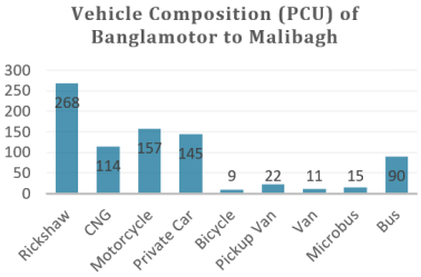
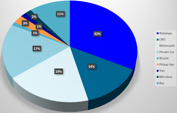
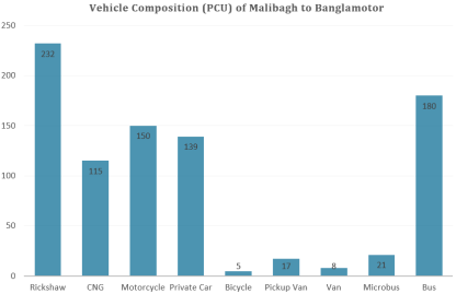
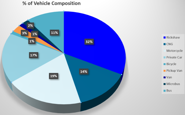
From the vehicle composition analysis using Passenger Car Equivalent (PCE) units, it was observed that rickshaws (32%), buses (21%), motorbikes (19%), and private cars (17%) occupy a major portion of the roadway space. Since rickshaws and buses have higher space requirements and different operating speeds compared to other vehicles, this mixed traffic condition reduces lane efficiency and interrupts smooth traffic flow. As a result, the high share of these vehicle types increases roadway occupancy, creates bottlenecks, and contributes significantly to traffic congestion on the route.
Figure 2. Vehicle Composition of Banglamotor to Malibagh.
Figure 3. Percentage of Vehicle Composition of Banglamotor to Malibagh.
Figure 4. Vehicle Composition of Malibagh to Banglamotor.
Figure 5. Percentage of Vehicle Composition of Malibagh to Banglamotor.
6.3. AADT Data Analysis
The Annual Average Daily Traffic (AADT) results show that the Malibagh to Bangla Motor direction carries 13,812 PCU per day, while the Bangla Motor to Malibagh direction carries 13,239 PCU per day. This indicates that traffic demand is comparatively higher in the Malibagh to Bangla Motor direction, meaning more vehicles use this route on a daily basis. As a result, this direction experiences greater roadway occupancy and higher traffic pressure, making it busier and more likely to face congestion than the opposite direction.
Table 2. AADT Data of Study Area.
Direction | AADT(PCU/Day) |
Malibagh to Bangla Motor | 13,812 |
Bangla Motor to Malibagh | 13,239 |
6.4. Parking Capacity and Road Width Percentage of Occupancy
Since the roadway width is not uniform throughout the selected study area, the route was divided into several sections for analysis. This sectional approach allows a clear comparison of variations in road width and the corresponding roadway space occupied for parking purpose. By examining each segment separately, it becomes easier to identify narrower bottleneck locations where traffic concentration is higher and congestion is more likely to occur.
Table 3. Parking Capacity and Roadway Width Occupancy Percentage (Banglamotor to Malibagh).
Location | Road Width (ft) | Control Point | Existing Parking Capacity (no. of vehicle) | Road width used for parking (ft) | % Of occupied road width |
Banglamotor to Moghbazar | 28 | Momotaz Mansion | No Parking | 7 | 25% |
Ispahani Girls School and College | No Parking | 12 | 42.86% |
Moghbazar Mor to Wireless | 30 | Moghbazar Mor | No Parking | 18 | 60% |
Club Ration Community Center | No Parking | 6 | 20% |
Wireless to Malibagh | 24 | Grand Plaza | 12 | 12 | 50% |
Eastern Bank Ltd. | No Parking | 5 | 20.83% |
Apex & Dorji- Bari | No Parking | 8 | 33.33% |
Hoshaf Tower | 50 | 9 | 37.5% |
Table 4. Parking Capacity and Roadway Width Occupancy Percentage (Malibagh to Banglamotor).
Location | Road Width (ft) | Control Point | Existing Parking Capacity (no. of vehicle) | Road width used for parking (ft) | % Of occupied road width |
Malibagh to Wireless | 24 | Hazi Mohiuddin Mansion | 10 | 6 | 25% |
Lili Plaza Market | No Parking | 5 | 20.83% |
Mouchak Market | No Parking | 8 | 33.33% |
Mentors | No Parking | 5 | 20.83% |
Wireless to Moghbazar Mor | 24 | Moghbazar Plaza | No Parking | 6 | 25% |
Uzzal Hotel and Resturant | No Parking | 6 | 25% |
Moghbazar Mor to Banglamotor | 28 | Oman Mansion | No Parking | 8 | 28.57% |
Mohosin Plaza | No Parking | 6 | 21.43% |
Auto-One Ac Market | 160 | 8 | 28.57% |
Eskaton Tower | No Parking | 5 | 17.86% |
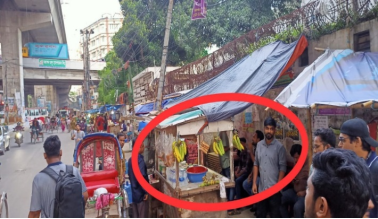
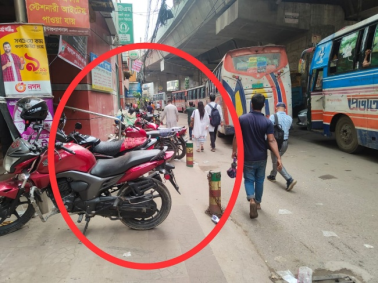
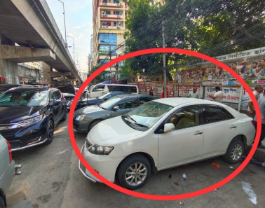
The findings indicate that approximately 20% to 60% of the roadway width is occupied, mainly due to on-street parking and roadside hawkers. Most market areas do not have adequate parking facilities; therefore, vehicles visiting these markets often park along the roadway. In addition, rickshaws are frequently parked at the road edges and near intersections, which further reduces the effective carriageway width and causes traffic queuing and congestion at several locations.
6.5. Demographic Data of the Respondents
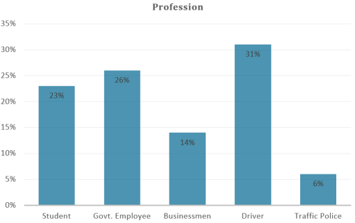
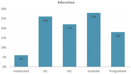
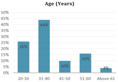
A total of 160 questionnaire responses were collected for this study, comprising 50 drivers, 50 pedestrians, 10 traffic police, and 50 passengers. A summary table is presented to show the percentage distribution of the respondents’ demographic characteristics. The demographic results indicate that approximately 44% of the participants were between 51 and 60 years of age, 31% were professional drivers, and 28% had completed graduate-level education. This distribution provides an overview of the respondent profile and supports the reliability of the perception-based findings from different road user groups.
Figure 6. Profession of respondents.
Figure 7. Education of respondents.
Figure 8. Age of respondents.
7. Survey Result Analysis7.1. Questionaries Survey
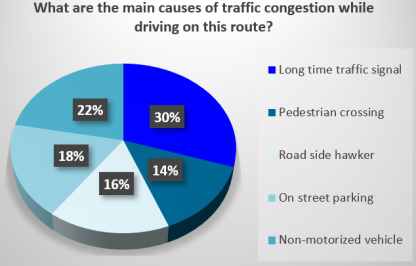
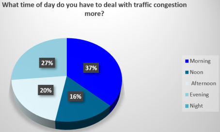
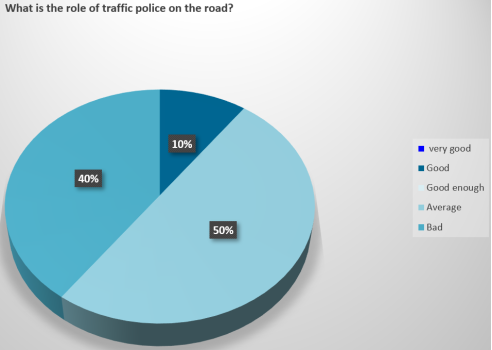
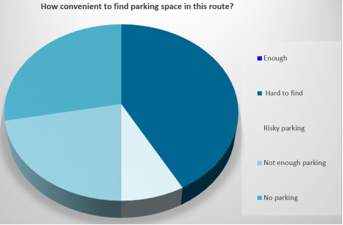
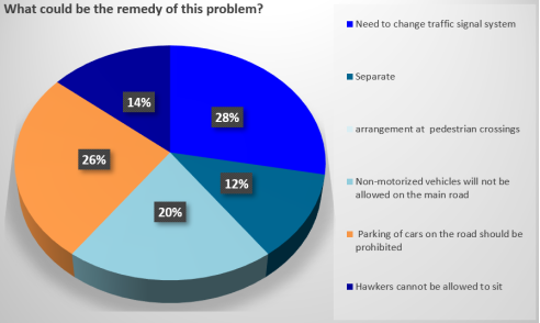
A questionnaire survey was conducted among 50 drivers who are using this study route. Approximately 30% of respondents identified prolonged waiting time at traffic signals as the primary cause of congestion, interference from non-motorized vehicles (22%), followed by on street parking (18%). Most respondents reported that congestion occurs predominantly during the morning peak period (37%), followed by the evening (27%) and afternoon (20%). The performance of traffic police was rated as average by about 50% of the respondents. In addition, 42% of participants reported difficulties in finding parking spaces along the route. As potential mitigation measures, respondents suggested improvements in traffic signal timing (28%), the prohibition of on-street parking (26%) and regulate movement of non-motorized vehicle (20%) to reduce traffic congestion. Pie chart of the responses from drivers are given below from
Figures 9-13.
Figure 9. Response of Drivers.
Figure 10. Response of Drivers.
Figure 11. Response of Drivers.
Figure 12. Response of Drivers.
Figure 13. Response of Drivers.
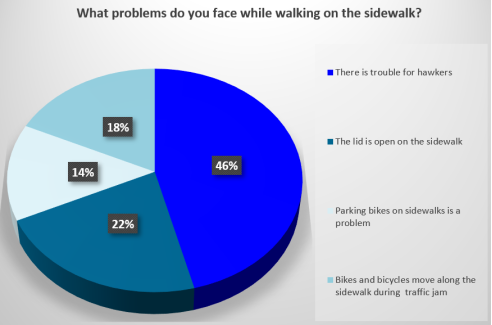
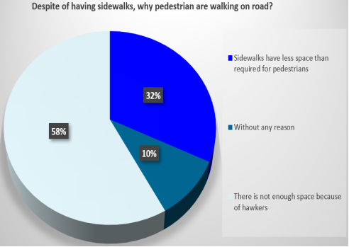
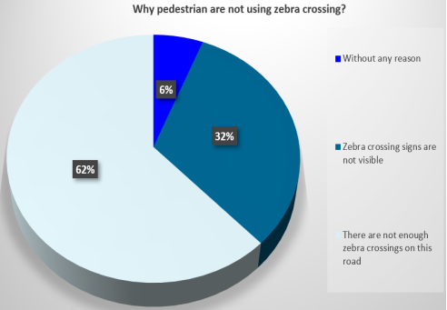
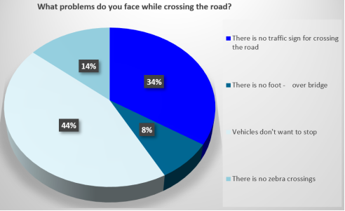
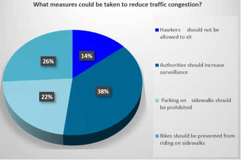
In addition, 50 pedestrians were asked to examine issues related to sidewalk use and road crossing behavior. A substantial proportion of respondents reported that sidewalk encroachment by roadside hawkers creates significant obstacles for pedestrians (46%), while open or improperly covered manhole lids were also identified as a concern (22%). More than half of the respondents (58%) indicated that inadequate sidewalk width, primarily due to hawker occupation, discourages them from using sidewalks. Furthermore, the absence of zebra crossings was cited by 62% of respondents as the main reason for not using designated pedestrian crossings. When asked about difficulties faced while crossing the road, respondents reported that vehicles often fail to stop for pedestrians (44%) and that traffic signs for pedestrian crossings are largely unavailable (34%). To address these issues, respondents suggested increasing traffic surveillance (38%) and restricting motorbike movement on sidewalks (26%) as potential measures to improve pedestrian safety and alleviate traffic congestion along the route. The responses collected from pedestrians are illustrated in the pie charts presented in
Figures 14-18.
Figure 14. Response of Pedestrians.
Figure 15. Response of Pedestrians.
Figure 16. Response of Pedestrians.
Figure 17. Response of Pedestrians.
Figure 18. Response of Pedestrians.
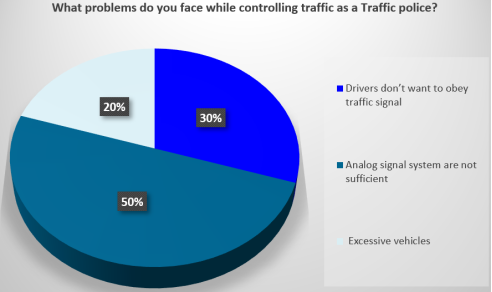
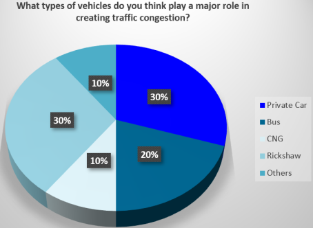
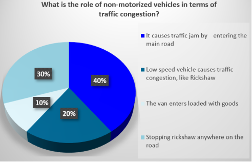
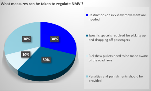
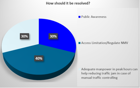
Field observations and survey responses indicate that only ten traffic police personnel were deployed at the study site during the observation period. Approximately 50% of respondents reported that the existing analog signal system is inadequate for effective traffic control, while 30% highlighted frequent non-compliance with traffic regulations by drivers. Private cars and rickshaws were each identified by 30% of respondents as major contributors to congestion. Additionally, 40% of respondents reported significant congestion associated with non-motorized vehicles (NMVs), primarily due to unregulated passenger pick-up and drop-off activities (30%). Proposed mitigation measures include restricting rickshaw movement (30%), providing designated pick-up and drop-off zones (30%), and strengthening enforcement through penalties (30%). Furthermore, limiting NMV access (40%), increasing public awareness (30%), and deploying additional traffic personnel during peak hours (30%) were suggested to improve traffic conditions along the route. The following pie charts shown in Figures 19–23 present the distribution of responses from traffic polices.
Figure 19. Response of Traffic Polices.
Figure 20. Response of Traffic Polices.
Figure 21. Response of Traffic Polices.
Figure 22. Response of Traffic Polices.
Figure 23. Response of Traffic Polices.
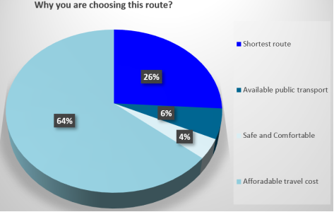
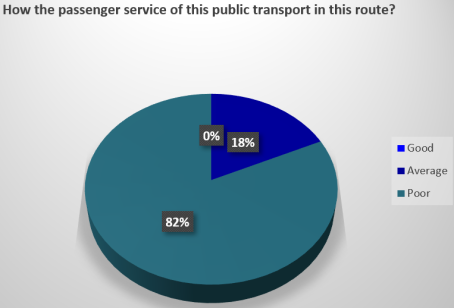
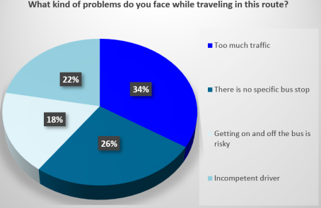
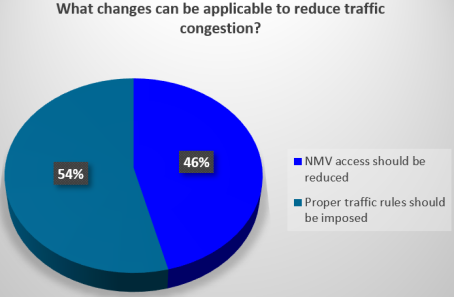
A questionnaire survey was conducted among 50 public transport passengers using the study route. The findings indicate that 64% of respondents prefer this route due to its affordability, while 26% select it as the shortest path to their destination. A substantial majority (82%) reported that the quality of passenger service is poor. The primary issues experienced by passengers include excessive traffic congestion (34%) and the absence of designated bus stopping areas (26%). Respondents suggested several improvement measures, including stricter enforcement of traffic regulations (54%) and reduction of non-motorized vehicle (NMV) access (46%) to enhance overall traffic conditions along the route. Passengers’ responses are given in the following section
Figures 24-27.
Figure 24. Response of Passengers.
Figure 25. Response of Passengers.
Figure 26. Response of Passengers.
Figure 27. Response of Passengers.
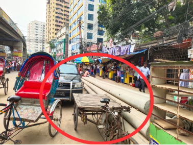
7.2. Photographic Survey
To complement the quantitative and survey findings, selected field photographs are included below to illustrate the on-site traffic conditions and issues such as roadside parking and lane encroachment.
Figure 28. Nonmotorized Vehicle parked in the roadside.
Figure 29. Small vendors using roadside.
Figure 30. Motorbikes parked on the sidewalk.
Figure 31. On street Parking.
8. Recommendation for Reducing Traffic Congestion
Based on the respondents’ suggestions, the following possible actions can be considered to reduce traffic congestion along the study route:
1)
Upgrading traffic signal systems: Replace the existing analog traffic signals with modern, adaptive signal control systems to reduce delays and improve intersection efficiency.
| [14] | Retting, R. A., Ferguson, S. A., Farmer, C. M. Reducing Red Light Running Through Longer Yellow Signal Timing and Red Light Camera Enforcement. Accident Analysis & Prevention. 2008, 40(1), 327–333.
https://doi.org/10.1016/j.aap.2007.07.001 |
[14]
2)
Strengthening traffic enforcement: Increase the number and effectiveness of traffic police to ensure stricter enforcement of traffic rules and improve overall traffic discipline.
3)
Regulating NMV movement: Implement proper control measures for non-motorized vehicles, especially during peak hours, to reduce mixed-traffic interference and improve traffic flow.
| [16] | Furth, P. G., Rahbee, A. Optimal Bus Stop Spacing Through Dynamic Programming and Geographic Modeling. Transportation Research Record. 2000, 1731(1), 15–22.
https://doi.org/10.3141/1731-03 |
[16]
4)
Establishing designated bus stops and loading zones: Provide well-planned bus stops and dedicated pick-up/drop-off areas to prevent random stopping of buses and private vehicles on the roadway.
5)
Improving public transport operations: Enhance bus service quality and management to reduce roadside congestion caused by irregular boarding and alighting of passengers.
| [18] | Zegeer, C. V., Stewart, J. R., Huang, H., Lagerwey, P. Safety Effects of Marked Versus Unmarked Crosswalks. Transportation Research Record. 2005, 1939(1), 56–68.
https://doi.org/10.3141/1939-07 |
[18]
6)
Enhancing pedestrian facilities: Remove sidewalk encroachments, widen sidewalks where feasible, and install zebra crossings and proper pedestrian signage to promote safe and organized pedestrian movement.
7)
Public awareness and behavior change programs: Implement sustained public awareness campaigns to improve compliance with traffic rules and promote responsible road user behavior. These can be carried out through school and university programs, community workshops, mass media campaigns (TV, radio, and social media), and targeted road safety education programs involving traffic authorities and local stakeholders.
8) viii)
Integrated traffic management approach: Implement a coordinated strategy combining infrastructure improvements, enforcement, and operational management to achieve long-term congestion reduction and improved road safety.
| [21] | De Luca, S., Di Pace, R., Memoli, S., & Pariota, L. (2020). Sustainable Traffic Management in an Urban Area: An Integrated Framework for Real-Time Traffic Control and Route Guidance Design. Sustainability, 12(2), 726.
https://doi.org/10.3390/su12020726 |
[21]
9. Discussion
Traffic congestion along the Banglamotor–Malibagh route is driven by the combined effects of infrastructural limitations, operational inefficiencies, and behavioral factors rather than a single cause. Traffic analysis indicates a clear mismatch between demand and available road capacity, leading to low travel speeds and frequent delays. Survey findings further highlight that ineffective signal operation, poor lane discipline, weak enforcement, and roadside parking significantly worsen congestion by reducing effective roadway width and interrupting traffic flow. In addition, unregulated pick-up and drop-off activities and the lack of organized public transport facilities create localized disruptions, while pedestrian encroachment onto roadways increases conflicts and further degrades traffic conditions.
The study also reveals that conventional traffic control measures are insufficient under highly congested and heterogeneous traffic conditions. These findings emphasize the need for an integrated traffic management approach that combines infrastructure improvement, better enforcement, and operational control. Therefore, more advanced and context-sensitive solutions, including adaptive signal control, improved enforcement strategies, and better integration of non-motorized and pedestrian facilities are necessary. Measures such as regulating on-street parking, providing designated stopping areas, improving public transport management and enhancing pedestrian facilities are essential to improve traffic flow and safety.
For future research, more detailed modeling approaches such as simulation-based analysis or trajectory-based safety assessment using advanced techniques like Extreme Value Theory can be employed to quantify the impact of different mitigation measures. Additionally, incorporating real-time traffic data and evaluating the effectiveness of proposed interventions through pilot implementations would provide more robust and practical insights.
10. Conclusion
This study identifies that traffic congestion along the Banglamotor to Malibagh route primarily stems from the imbalance between traffic demand and available road capacity, compounded by poor traffic operations and roadside disruptions. Issues such as uncontrolled parking, irregular stopping of vehicles, weak enforcement, and inadequate pedestrian facilities further intensify the problem.
Addressing these challenges requires coordinated measures, including better traffic control systems, regulated parking and stopping practices, improved public transport management, and safer pedestrian infrastructure. Implementing these strategies can enhance mobility, reduce delays, and contribute to a more efficient and sustainable urban transport system.
Abbreviations
V/C | Volume to Capacity |
LOS | Level of Service |
TIA | Traffic Impact Assessment |
SEM | Structural Equation Modelling |
Author Contributions
Anika Nowshin Mowrin: Conceptualization, Supervision, Writing – original draft, Writing – review & editing
Kamruzzaman Haque Limon: Writing – review & editing
Azaz Ahmmed: Data curation, Formal Analysis, Investigation
Mohammad Asadujjaman Anik: Data curation, Formal Analysis, Investigation
Conflicts of Interest
The authors declare no conflicts of interest.
Data Availability Statement
The data supporting the outcome of this research work has been reported in this manuscript.
References
| [1] |
Ali, Y., Rafay, M., Khan, R. D. A., Sorn, M. K., Jiang, H. Traffic Problems in Dhaka City: Causes, Effects, and Solutions (Case Study to Develop a Business Model). Open Access Library Journal. 2023, 10, e9994.
https://doi.org/10.4236/oalib.1109994
|
| [2] |
Haider, M. Z., Papri, R. S. Cost of Traffic Congestion in Dhaka Metropolitan City. Public Transport. 2021, 13, 287–299.
https://doi.org/10.1007/s12469-021-00270-4
|
| [3] |
Islam, K. R., Yeasmin, K. M. Behavioral Aspects of Drivers as Contributing to Traffic Jam: The Case of Dhaka City’s Bus Drivers. The Chittagong University Journal of Social Sciences. 2025, 34, 1–16.
|
| [4] |
Ali, M., Ahsan, G. U., Hossain, A. Traffic Congestion and Physical Health of Commuters: Perspective of Dhaka City. Journal of Contemporary Studies in Epidemiology and Public Health. 2021, 2.
https://doi.org/10.30935/jconseph/9365
|
| [5] |
Abir, A. T. M., Rahman, M. M., Islam, F., Bashar, R., Islam, S. User Response–Based Sustainable Solutions to Traffic Congestion Problem Using Public Transport: The Case of Uttara, Dhaka. International Journal of Transportation Engineering and Technology. 2018, 4(2), 23–30.
https://doi.org/10.5923/j.ijtte.20180702.03
|
| [6] |
Al-Qadery, S. M. A., Muhibbullah, M. People’s Perception on Urban Traffic Congestion: A Case Study on Chittagong Metropolitan City, Bangladesh. Chittagong University Journal of Biological Sciences. 2013, 8(1–2), 45–60.
https://doi.org/10.3329/cujbs.v3i1.13415
|
| [7] |
Das, P., Debnath, B., Hoque, I., Islam, S. Assessing the Potential of Shared Mobility to Alleviate Traffic Congestion: A Traffic Survey and Simulation Study in Dhaka. Proceedings of ICERIE 2025. 2025.
https://doi.org/10.2991/978-94-6463-884-4_20
|
| [8] |
Rahman, A., Hoque, A. K. M. F. Traffic Congestion in Dhaka City: Potential Solutions. European Journal of Social Sciences Studies. 2018, 3(2), 1–15.
http://dx.doi.org/10.46827/ejsss.v0i0.371
|
| [9] |
Salehin, M. S., Jubailee, T., Sourav, M. M. I., et al. A Structural Equation Modeling Approach to Understand Users’ Perceptions of App-Based CNG Auto-Rickshaw Services in Dhaka City. Journal of Engineering and Applied Science. 2024, 71, Article 45.
https://doi.org/10.1186/s44147-024-00368-z
|
| [10] |
Sharmeen, N., Sadat, K., Zaman, N., Mitra, S. K. Developing a Generic Methodology for Traffic Impact Assessment of a Mixed Land Use in Dhaka City. Journal of Bangladesh Institute of Planners. 2012, 5, 55–66.
https://doi.org/10.3329/jbip.v5i1.77026
|
| [11] |
Subair, S. O., Ibitoye, B. A., Kuranga, A. T. Evaluation of Traffic Congestion in Urban Roads: A Review. ABUAD Journal of Engineering and Applied Sciences. 2024, 2(1), 12–25.
https://doi.org/10.53982/ajeas.2024.0202.01-j
|
| [12] |
Parkavi, S. P., Angamuthu, P. Assessing Urban Traffic Congestion for Sustainable Transportation in Chennai, India. Frontiers in Sustainable Cities. 2025, 7, 1684489.
https://doi.org/10.3389/frsc.2025.1684489
|
| [13] |
Jing, P., Huang, H., Chen, L. An Adaptive Traffic Signal Control in a Connected Vehicle Environment: A Systematic Review. Information. 2017, 8(3), 101.
https://doi.org/10.3390/info8030101
|
| [14] |
Retting, R. A., Ferguson, S. A., Farmer, C. M. Reducing Red Light Running Through Longer Yellow Signal Timing and Red Light Camera Enforcement. Accident Analysis & Prevention. 2008, 40(1), 327–333.
https://doi.org/10.1016/j.aap.2007.07.001
|
| [15] |
Tiwari, G. Non-Motorized Transport and Sustainable Urban Transport. Transport Reviews. 2013, 33(1), 1–10.
https://doi.org/10.1080/01441647.2012.745732
|
| [16] |
Furth, P. G., Rahbee, A. Optimal Bus Stop Spacing Through Dynamic Programming and Geographic Modeling. Transportation Research Record. 2000, 1731(1), 15–22.
https://doi.org/10.3141/1731-03
|
| [17] |
Eboli, L., Mazzulla, G. Service Quality Attributes Affecting Customer Satisfaction for Bus Transit. Transport Policy. 2007, 14(1), 21–34.
https://doi.org/10.1016/j.tranpol.2006.10.004
|
| [18] |
Zegeer, C. V., Stewart, J. R., Huang, H., Lagerwey, P. Safety Effects of Marked Versus Unmarked Crosswalks. Transportation Research Record. 2005, 1939(1), 56–68.
https://doi.org/10.3141/1939-07
|
| [19] |
Phillips, R. O., Ulleberg, P., Vaa, T. Meta-Analysis of the Effect of Road Safety Campaigns. Accident Analysis & Prevention. 2011, 43(3), 1204–1218.
https://doi.org/10.1016/j.aap.2010.12.020
|
| [20] |
Banister, D. The Sustainable Mobility Paradigm. Transport Policy. 2008, 15(2), 73–80.
https://doi.org/10.1016/j.tranpol.2007.10.005
|
| [21] |
De Luca, S., Di Pace, R., Memoli, S., & Pariota, L. (2020). Sustainable Traffic Management in an Urban Area: An Integrated Framework for Real-Time Traffic Control and Route Guidance Design. Sustainability, 12(2), 726.
https://doi.org/10.3390/su12020726
|
Cite This Article
-
APA Style
Mowrin, A. N., Limon, K. H., Ahmmed, A., Anik, M. A. (2026). Integrating Engineering Surveys and User Perceptions to Assess Traffic Congestion: A Case Study of Dhaka City. International Journal of Transportation Engineering and Technology, 12(2), 57-75. https://doi.org/10.11648/j.ijtet.20261202.11
 Copy
|
Copy
|
 Download
ACS Style
Mowrin, A. N.; Limon, K. H.; Ahmmed, A.; Anik, M. A. Integrating Engineering Surveys and User Perceptions to Assess Traffic Congestion: A Case Study of Dhaka City. Int. J. Transp. Eng. Technol. 2026, 12(2), 57-75. doi: 10.11648/j.ijtet.20261202.11
Copy
|
Download
AMA Style
Mowrin AN, Limon KH, Ahmmed A, Anik MA. Integrating Engineering Surveys and User Perceptions to Assess Traffic Congestion: A Case Study of Dhaka City. Int J Transp Eng Technol. 2026;12(2):57-75. doi: 10.11648/j.ijtet.20261202.11
Copy
|
Download
-
@article{10.11648/j.ijtet.20261202.11,
  author = {Anika Nowshin Mowrin and Kamruzzaman Haque Limon and Azaz Ahmmed and Mohammad Asadujjaman Anik},
  title = {Integrating Engineering Surveys and User Perceptions to Assess Traffic Congestion: A Case Study of Dhaka City},
  journal = {International Journal of Transportation Engineering and Technology},
  volume = {12},
  number = {2},
  pages = {57-75},
  doi = {10.11648/j.ijtet.20261202.11},
  url = {https://doi.org/10.11648/j.ijtet.20261202.11},
  eprint = {https://article.sciencepublishinggroup.com/pdf/10.11648.j.ijtet.20261202.11},
  abstract = {Traffic congestion is a major urban transportation challenge in Dhaka, particularly along key arterial routes. This study assesses traffic congestion along the Banglamotor–Malibagh route using traffic performance analysis and questionnaire-based surveys. Field observations indicate severely degraded operating conditions, with volume-to-capacity (V/C) ratios of 1.01 and 1.04 in the two directions, confirming that traffic demand exceeds available roadway capacity. The route operates at Level of Service (LOS) F, characterized by unstable flow, frequent interrupted flow conditions, and low average speeds of 13.30 mph and 13.23 mph in the respective directions. Traffic composition analysis reveals that rickshaws, motorcycles and buses are the predominant contributors to congestion. In addition, on-street parking and roadside activities reduce effective carriageway width by approximately 20%–60%, further constraining capacity. A structured questionnaire survey conducted among route users including drivers, pedestrians, traffic police, and passengers reveals that non-motorized vehicles, inadequate pedestrian safety and uncontrolled passenger pick-up and drop-off activities are major operational challenges. Major findings of the study highlight that congestion is not solely a capacity issue but is strongly influenced by unmanaged mixed traffic operations and roadside disruptions. The study emphasizes that without proper regulation and coordination, infrastructure improvements alone are insufficient to address congestion. To improve traffic conditions, the study recommends signal optimization, control of non-motorized and slow-moving vehicles, provision of designated stopping areas and strengthened traffic management and enforcement. An integrated and coordinated approach is essential to enhance mobility and ensure sustainable transport performance along the route.},
 year = {2026}
}
Copy
|
Download
-
TY  - JOUR
T1  - Integrating Engineering Surveys and User Perceptions to Assess Traffic Congestion: A Case Study of Dhaka City
AU  - Anika Nowshin Mowrin
AU  - Kamruzzaman Haque Limon
AU  - Azaz Ahmmed
AU  - Mohammad Asadujjaman Anik
Y1  - 2026/05/14
PY  - 2026
N1  - https://doi.org/10.11648/j.ijtet.20261202.11
DO  - 10.11648/j.ijtet.20261202.11
T2  - International Journal of Transportation Engineering and Technology
JF  - International Journal of Transportation Engineering and Technology
JO  - International Journal of Transportation Engineering and Technology
SP  - 57
EP  - 75
PB  - Science Publishing Group
SN  - 2575-1751
UR  - https://doi.org/10.11648/j.ijtet.20261202.11
AB  - Traffic congestion is a major urban transportation challenge in Dhaka, particularly along key arterial routes. This study assesses traffic congestion along the Banglamotor–Malibagh route using traffic performance analysis and questionnaire-based surveys. Field observations indicate severely degraded operating conditions, with volume-to-capacity (V/C) ratios of 1.01 and 1.04 in the two directions, confirming that traffic demand exceeds available roadway capacity. The route operates at Level of Service (LOS) F, characterized by unstable flow, frequent interrupted flow conditions, and low average speeds of 13.30 mph and 13.23 mph in the respective directions. Traffic composition analysis reveals that rickshaws, motorcycles and buses are the predominant contributors to congestion. In addition, on-street parking and roadside activities reduce effective carriageway width by approximately 20%–60%, further constraining capacity. A structured questionnaire survey conducted among route users including drivers, pedestrians, traffic police, and passengers reveals that non-motorized vehicles, inadequate pedestrian safety and uncontrolled passenger pick-up and drop-off activities are major operational challenges. Major findings of the study highlight that congestion is not solely a capacity issue but is strongly influenced by unmanaged mixed traffic operations and roadside disruptions. The study emphasizes that without proper regulation and coordination, infrastructure improvements alone are insufficient to address congestion. To improve traffic conditions, the study recommends signal optimization, control of non-motorized and slow-moving vehicles, provision of designated stopping areas and strengthened traffic management and enforcement. An integrated and coordinated approach is essential to enhance mobility and ensure sustainable transport performance along the route.
VL  - 12
IS  - 2
ER  -
Copy
|
Download