Abstract
This study presents a system architecture, algorithm, and evaluation protocol for smart agriculture and environmental monitoring. It is a method/architecture contribution and does not report field trial results. World food production is still under stress from climate variability, the availability of freshwater resources, and the cost of farm inputs, offering an incentive to transition to data-driven and sensor-based farm management practices. Internet of Things (IoT)-based agricultural monitoring is well developed, but most systems deployed focus on a single parameter (e.g., soil moisture) or the parameter is inferred solely in the cloud, adding latency and fragility to the deployment of systems in rural areas. In this study, we propose an integrated architecture for low-power multiparameter environmental sensing, LoRaWAN/NB-IoT connectivity, edge-based lightweight inference, and privacy-preserving federated learning with cross-farm model aggregation, which is further complemented by a digital twin layer for scenario simulation. The decision layer of the framework can combine data from ground sensors with UAV and satellite images for the multi-scale monitoring of crop health and environmental quality (air, water, and GHG proxies). We contribute the full system design, an algorithmic pipeline, a sensor and model configuration specification, and a pre-registered evaluation protocol intended to guide future field deployment; no field data have yet been collected and clearly labelled non-empirical templates showing the expected reporting format only, rather than measured outcomes. The architecture and protocol are instead grounded in, and cross-checked against, published state-of-the-art results, which report an accuracy range of 82–97% for federated crop-yield prediction and 20–30% water savings from sensor-controlled irrigation.
Keywords
Smart Agriculture, Internet of Things, Environmental Monitoring, Precision Farming, Edge AI, LoRaWAN,
Federated Learning, Digital Twin, UAV-Satellite Fusion, Sustainability
1. Introduction
By mid-century, the world population is projected to reach 10 billion, which will further increase the demand for food and, consequently, water, soil, and energy resources
| [17] | “Agricultural digital twin for smart farming: A comprehensive review,” 2026. |
[17]
. Irrigation efficiency is a key factor in driving sustainable water use in agriculture, as it accounts for approximately 70% of global freshwater withdrawals
| [27] | A. A. Abdelmoneim, H. N. Kimaita, C. M. Al Kalaany, B. Derardja, G. Dragonetti, and R. Khadra, “IoT sensing for advanced irrigation management: A systematic review of trends, challenges, and future prospects,” Sensors, vol. 25, no. 7, Art. no. 2291, 2025, https://doi.org/10.3390/s25072291 |
[27].
Meanwhile, the global IoT in the agricultural market is expected to expand significantly in the coming decade, driven by the rapid progress of commercial and research activities in this sector
| [27] | A. A. Abdelmoneim, H. N. Kimaita, C. M. Al Kalaany, B. Derardja, G. Dragonetti, and R. Khadra, “IoT sensing for advanced irrigation management: A systematic review of trends, challenges, and future prospects,” Sensors, vol. 25, no. 7, Art. no. 2291, 2025, https://doi.org/10.3390/s25072291 |
[27]
.
There has been considerable recent research on how water-inefficient irrigation systems can be automated using low-cost capacitive and/or resistive soil-moisture sensors, combined with LoRaWAN or NB-IoT connectivity, thus preventing water waste
| [4] | O. H. Kombo, S. Kumaran, and A. Bovim, “Design and application of a low-cost, low-power, LoRa-GSM, IoT-enabled system for monitoring of groundwater resources with energy harvesting integration,” IEEE Access, vol. 9, pp. 128417–128433, 2021. |
| [8] | T. Ebstu et al., “Development and testing of a low-cost soil moisture sensor for real-time irrigation scheduling,” Irrigation and Drainage, vol. 75, no. 1, pp. 173–187, 2026,
https://doi.org/10.1002/ird.70026 |
| [9] | “A monitoring method for agricultural soil moisture using wireless sensors and the Biswas model,” Agriculture, vol. 15, no. 3, Art. no. 344, 2025. |
[4, 8, 9]
. Complementary studies have been performed to enable the monitoring of the environment and plant health, in addition to irrigation control, by combining temperature, humidity, soil-nutrient (NPK), and gas sensors with machine-learning classifiers
| [1] | M. J. H. Emon and S. S. Ahmed, “Integration of IoT, machine learning, and sensors for intelligent environmental monitoring and agricultural development,” Journal of Computer Networks and Communications, vol. 2025, Art. no. 6611890, 2025, https://doi.org/10.1155/jcnc/6611890 |
| [2] | “A survey on IoT-based smart farming systems for automated irrigation and real-time soil monitoring,” International Journal of Engineering Research & Technology (IJERT), 2024–2025. |
| [3] | “Smart sensors and smart data for precision agriculture: A review,” Sensors/MDPI, 2024. |
[1-3]
. However, three limitations have been reported in the literature. First, most are single-farm cloud-based pipelines that have latency and connectivity problems in remote areas
| [7] | “Research and development of an IoT smart irrigation system for farmland based on LoRa and edge computing,” Agriculture, vol. 15, no. 2, Art. no. 366, 2025. |
[7]
. Second, although remote-sensing data from satellites, UAVs, and ground-level platforms have been shown to have benefits when combined in the context of improving the accuracy of the vegetation index when compared to data from single platforms, few architectures combine all three platforms for multi-scale validation. Third, collaborative learning across farms is vital for making models generalizable to different soil conditions and climates, but is not supported by centralized ML due to data privacy concerns, making Federated Learning (FL) a growing popular paradigm in the crop-yield-prediction literature
| [10] | A. Mukherjee et al., “Federated learning architectures: A performance evaluation with crop yield prediction application,” Software: Practice and Experience, 2025. |
| [11] | V. Hiremani, R. M. Devadas, Preethi, R. Sapna, T. Sowmya, P. Gujjar, N. Shobha Rani, and K. R. Bhavya, “Federated learning for crop yield prediction: A comprehensive review of techniques and applications,” MethodsX, vol. 14, Art. no. 103408, 2025, https://doi.org/10.1016/j.mex.2025.103408 |
| [12] | U. Nirosha and G. Vennila, “Enhancing crop yield prediction for agriculture productivity using federated learning integrating with graph and recurrent neural networks model,” Expert Systems with Applications, vol. 289, Art. no. 128312, 2025,
https://doi.org/10.1016/j.eswa.2025.128312 |
[10-12]
.
1.1. Problem Statement
Although significant strides are being made in each of the individual subareas (sensing, connectivity, edge AI, federated learning, digital twins, and remote-serving fusion), no validated architecture has been developed that brings together all six layers to form a single field-deployable and privacy-preserving pipeline for combined agriculture and environmental monitoring. This disparity hampers the scalability of smallholder networks, which constitute the largest proportion of farms worldwide, particularly those with insufficient connectivity and computing power.
1.2. Research Questions
RQ1: Can a reduction in inference latency and bandwidth be achieved compared with cloud-only baselines with a layered edge-cloud architecture, and can a comparable accuracy of the predictions be achieved to centralized architectures?
RQ2: Is there any loss of accuracy in the federated training compared to the centralized training, and does it maintain most of the accuracy as reported recently in the agricultural context (82–97%) without sharing raw data across multiple simulated farm nodes?
RQ3: Is there a benefit in integrating ground-sensor-based data with data derived from UAVs and/or satellite-derived vegetation indices for detecting water and/or nutrient stress at an early stage compared with collecting data from ground sensors alone?
1.3. Contributions
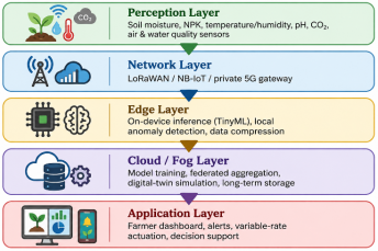
1) Multi-parameter environmental sensing technology for LoRaWAN/NB-IoT, namely, a five-layer reference architecture connecting the perception, network, edge, cloud/fog, and application layers.
2) Compressed LSTM network: A lightweight edge-deployable sequence model that can be used for on-node inference.
3) Softwarized LSTM network: a lightweight, edge-deployable sequence model for on-node inference, combined with a federated averaging protocol for privacy-preserving cross-farm learning.
4) Digital twin simulation layer that consumes fused UAV/satellite and ground sensor data to aid predictive what-if scenario analysis.
5) A well-documented, repeatable assessment process (metrics, baselines, and splits) and a special illustrative template of results to be filled with actual field data.
Figure . 1. Layered system architecture: perception → network → edge → cloud/fog → application.. Layered system architecture: perception → network → edge → cloud/fog → application.
2. Related Works
2.1. IoT Sensing and Low-Power Connectivity
The most developed part of the agricultural Internet of Things is soil-moisture sensing. Ebstu et al.
| [8] | T. Ebstu et al., “Development and testing of a low-cost soil moisture sensor for real-time irrigation scheduling,” Irrigation and Drainage, vol. 75, no. 1, pp. 173–187, 2026,
https://doi.org/10.1002/ird.70026 |
[8]
designed and validated a low-cost soil moisture (ASM) sensor with LoRaWAN gateways compared to a premium sensor (PSM) in two seasons of wheat cultivation and obtained similar accuracy at a much lower cost. Likewise, when estimating soil-moisture storage at shallow depths (down to 2 m) using shallow LoRa sensor data, a BISWAS-based WSN obtained a coefficient of determination of more than 0.94. In the connectivity layer, Kombo et al.
| [4] | O. H. Kombo, S. Kumaran, and A. Bovim, “Design and application of a low-cost, low-power, LoRa-GSM, IoT-enabled system for monitoring of groundwater resources with energy harvesting integration,” IEEE Access, vol. 9, pp. 128417–128433, 2021. |
[4]
presented a LoRa-GSM node for groundwater monitoring that was powered from energy harvesting for unattended operation in rural areas, and Ali et al.
| [5] | S. Ali, T. Glass, B. Parr, J. Potgieter, and F. Alam, “Low cost sensor with IoT LoRaWAN connectivity and machine learning-based calibration for air pollution monitoring,” IEEE Transactions on Instrumentation and Measurement, vol. 70, pp. 1–11, 2021, https://doi.org/10.1109/TIM.2020.3034109 |
[5]
illustrated that low-cost LoRaWAN air-quality sensors can be calibrated by machine learning and can achieve reference-instrument accuracy, while environmental monitoring nodes using LoRaWAN have been shown in the adjacent municipal-sensing applications, with similar duty-cycle and range constraints
| [6] | S. R. Jino Ramson, S. Vishnu, A. A. Kirubaraj, T. Anagnostopoulos, and A. M. Abu-Mahfouz, “A LoRaWAN IoT-enabled trash bin level monitoring system,” IEEE Transactions on Industrial Informatics, vol. 18, no. 2, pp. 786–795, 2022,
https://doi.org/10.1109/TII.2021.3078556 |
[6]
. A distributed irrigation system based on 2025 LoRa/edge-computing further embedded decision-making at the gateway level, bypassing the necessity of relying on cloud-based analytics to solve latency issues alluded to throughout this literature
| [7] | “Research and development of an IoT smart irrigation system for farmland based on LoRa and edge computing,” Agriculture, vol. 15, no. 2, Art. no. 366, 2025. |
[7]
.
2.2. Machine Learning and Edge AI for Agricultural Decision Support
Machine learning has evolved from a mere irrigation control system with threshold parameters to a classifier/regressor-based decision support system for irrigation control beyond raw sensing. Multi-sensor and image data are employed for extracting features using a VGG16-derived feature pipeline, followed by classifiers (Random Forest and XGBoost) to assess the plant health status
| [1] | M. J. H. Emon and S. S. Ahmed, “Integration of IoT, machine learning, and sensors for intelligent environmental monitoring and agricultural development,” Journal of Computer Networks and Communications, vol. 2025, Art. no. 6611890, 2025, https://doi.org/10.1155/jcnc/6611890 |
[1]
. Edge deployment has begun to strike with a report to provide context-aware, low-latency inference in the field, not round-trip calls to the cloud, of an automated IoT actuation/reporting system based on a rule-based agentic decision engine and lightweight deep-learning crop/weather classifiers
| [16] | M. U. Tariq, S. M. Saqib, T. Mazhar, M. A. Khan, T. Shahzad, and H. Hamam, “Edge-enabled smart agriculture framework: Integrating IoT, lightweight deep learning, and agentic AI for context-aware farming,” Results in Engineering, vol. 28, Art. no. 107342, 2025,
https://doi.org/10.1016/j.rineng.2025.107342 |
[16]
. More comprehensive evaluations of AI-based methods for yield prediction have yielded R2 scores of 0.88–0.94 and RMSE reductions of 18–25% compared to single-model predictions
| [25] | G. C. Hernández Hernández, J. Gómez Gómez, and J. Jiménez-Cabas, “Predictive models based on artificial intelligence to estimate crop yield: A literature review,” Agriculture, vol. 15, no. 23, Art. no. 2438, 2025,
https://doi.org/10.3390/agriculture15232438 |
[25]
.
2.3. Federated Learning for Privacy-Preserving Cross-Farm Modeling
The specific need for data sharing reluctance in individual farms has led to the creation of federated learning. Federated learning has come into existence specifically to move past data sharing reluctance among individual farms. The centralized and decentralized FL architectures for crop-yield prediction using LSTM/GRU yielded a high accuracy of over 93% (centralized) and over 97.5% (decentralized) with smaller response time than the non-federated baselines, as reported by Mukherjee et al.
| [10] | A. Mukherjee et al., “Federated learning architectures: A performance evaluation with crop yield prediction application,” Software: Practice and Experience, 2025. |
[10]
. A detailed review of FL's foundations and limitations in 2025 identified FL's mathematical challenges and practical constraints – most notably communication overhead and data heterogeneity across the farms that is not IID – as the most open problems
| [11] | V. Hiremani, R. M. Devadas, Preethi, R. Sapna, T. Sowmya, P. Gujjar, N. Shobha Rani, and K. R. Bhavya, “Federated learning for crop yield prediction: A comprehensive review of techniques and applications,” MethodsX, vol. 14, Art. no. 103408, 2025, https://doi.org/10.1016/j.mex.2025.103408 |
[11]
. In both references
| [13] | T. Manoj, K. Makkithaya, and V. G. Narendra, “A federated learning-based crop yield prediction for agricultural production risk management,” in Proc. IEEE Delhi Section Conf. (DELCON), 2022, pp. 1–7. |
[13]
and
| [14] | T. Dey, S. Bera, B. Paul, D. De, A. Mukherjee, and R. Buyya, “Fly: Femtolet-based edge-cloud framework for crop yield prediction using bidirectional long short-term memory,” Software: Practice and Experience, vol. 54, no. 8, pp. 1361–1377, 2024, https://doi.org/10.1002/spe.3324 |
[14]
, FL is combined with edge computing, with a gradient encryption (AES-256/RSA) approach for the latter, which results in lower latency and energy consumption compared to a conventional edge-cloud pipeline. To date, a privacy-preserving FL system has been validated on 450 smallholder farms in India, Kenya, and Nigeria, with 87.3% yield-prediction accuracy while guaranteeing differential privacy (DP), and importantly, 82.6% accuracy with only 200 samples per farm, typical of smallholder operations
| [15] | “Privacy-preserving federated learning framework for sustainable crop yield prediction across distributed smallholder farm networks,” Journal of Scientific Research and Technology, 2026. |
[15]
).
2.4. Digital Twins and Multi-Scale Remote-Sensing Fusion
Digital-twin (DT) technology is no longer in concept review but has begun operational deployment in agriculture. In 2026, a scoping review revealed that plant-level and soil-moisture models were the focus of DT publications, with many using the term loosely to refer to decision-support tools but not fully synchronized bidirectional virtual–physical systems
. Other, more comprehensive reviews also highlight applications of DT in irrigation/nutrient management and crop-growth simulation that combine data from soil, plant, and weather sources
| [19] | “Digital twins in agriculture: Orchestration and applications,” 2024. |
| [20] | N. Peladarinos et al., “Enhancing smart agriculture by implementing digital twins: A comprehensive review,” Sensors, vol. 23, no. 16, Art. no. 7128, 2023,
https://doi.org/10.3390/s23167128 |
[19, 20]
. On the remote sensing side, fusion of UAV and Sentinel-2 satellite images using Brovey Transform and PCA techniques has proven to be a combination of UAV spatio-temporal resolution with Sentinel-2 spectro-temporal resolution, which has increased the accuracy of vegetation indices (NDVI, GNDVI, SAVI) in detecting crop stress
| [21] | A. R. Allu and S. Mesapam, “Fusion of satellite and UAV imagery for crop monitoring,” ISPRS Annals of the Photogrammetry, Remote Sensing and Spatial Information Sciences, vol. X-G-2025, pp. 71–79, 2025. |
[21]
. A 2025 systematic review of UAV-satellite integration techniques highlighted pixel-, feature-, and decision-level fusion as the main integration paradigms
| [22] | “Optimizing integration techniques for UAS and satellite image data in precision agriculture—A review,” Frontiers in Remote Sensing, vol. 6, 2025. |
[22]
, and UAV-IoT-AI integration studies show up to 92% accuracy in forest/crop deterioration detection when combining high-resolution satellite and ground IoT data
| [23] | A. B. Rashid, A. K. Kausik, A. Khandoker, and S. N. Siddque, “Integration of artificial intelligence and IoT with UAVs for precision agriculture,” Hybrid Advances, vol. 10, Art. no. 100458, Sep. 2025,
https://doi.org/10.1016/j.hybadv.2025.100458 |
[23]
, and finally, multispectral UAV remote-sensing reviews confirm the value-added benefits of spectral-band selection for early stress detection
| [24] | “A review of the application of UAV multispectral remote sensing technology in precision agriculture,” 2025. |
[24]
.
Table 1. Comparative Summary of Related Work.
Ref | Year | Core Technology | Application Focus | Reported Outcome | Gap Addressed Here |
| [8] | T. Ebstu et al., “Development and testing of a low-cost soil moisture sensor for real-time irrigation scheduling,” Irrigation and Drainage, vol. 75, no. 1, pp. 173–187, 2026,
https://doi.org/10.1002/ird.70026 |
[8] | 2026 | Low-cost ASM sensor + LoRaWAN | Soil moisture, wheat irrigation | Comparable accuracy to premium sensors | No edge AI / no FL |
| [9] | “A monitoring method for agricultural soil moisture using wireless sensors and the Biswas model,” Agriculture, vol. 15, no. 3, Art. no. 344, 2025. |
[9] | 2025 | LoRa WSN + Biswas model | Root-zone moisture estimation | R² > 0.94 | Single-parameter only |
| [7] | “Research and development of an IoT smart irrigation system for farmland based on LoRa and edge computing,” Agriculture, vol. 15, no. 2, Art. no. 366, 2025. |
[7] | 2025 | LoRa + edge computing | Irrigation decision at gateway | Reduced cloud dependency | No federated cross-farm learning |
| [1] | M. J. H. Emon and S. S. Ahmed, “Integration of IoT, machine learning, and sensors for intelligent environmental monitoring and agricultural development,” Journal of Computer Networks and Communications, vol. 2025, Art. no. 6611890, 2025, https://doi.org/10.1155/jcnc/6611890 |
[1] | 2025 | Multi-sensor + RF/XGBoost + VGG16 | Plant-health classification | High classification accuracy | No connectivity-layer optimization |
| [10] | A. Mukherjee et al., “Federated learning architectures: A performance evaluation with crop yield prediction application,” Software: Practice and Experience, 2025. |
[10] | 2025 | Centralized/decentralized FL, LSTM/GRU | Crop-yield prediction | 93–97.5% accuracy | No sensor/edge integration |
| [13] | T. Manoj, K. Makkithaya, and V. G. Narendra, “A federated learning-based crop yield prediction for agricultural production risk management,” in Proc. IEEE Delhi Section Conf. (DELCON), 2022, pp. 1–7. |
[13] | 2022/24 | FL + edge + gradient encryption | Yield prediction, privacy | −39% latency, −40% energy | No remote-sensing fusion |
| [14] | T. Dey, S. Bera, B. Paul, D. De, A. Mukherjee, and R. Buyya, “Fly: Femtolet-based edge-cloud framework for crop yield prediction using bidirectional long short-term memory,” Software: Practice and Experience, vol. 54, no. 8, pp. 1361–1377, 2024, https://doi.org/10.1002/spe.3324 |
[14] | 2026 | FL + differential privacy, 450 farms | Smallholder yield prediction | 82.6–87.3% accuracy | No digital twin / UAV layer |
| [17] | “Agricultural digital twin for smart farming: A comprehensive review,” 2026. |
[17] | 2026 | Digital twin scoping review | Plant/soil DT models | Conceptual maturity assessment | Mostly conceptual, few field DTs |
| [20] | N. Peladarinos et al., “Enhancing smart agriculture by implementing digital twins: A comprehensive review,” Sensors, vol. 23, no. 16, Art. no. 7128, 2023,
https://doi.org/10.3390/s23167128 |
[20] | 2025 | UAV + Sentinel-2 fusion (BT, PCA) | Vegetation-index accuracy | Improved NDVI/GNDVI accuracy | No FL or edge integration |
| [15] | “Privacy-preserving federated learning framework for sustainable crop yield prediction across distributed smallholder farm networks,” Journal of Scientific Research and Technology, 2026. |
[15] | 2025 | Edge DL + agentic AI | Context-aware actuation | Low-latency field decisions | No multi-farm learning, no DT |
3. Methodology
3.1. Perception Layer - Multi-Parameter Sensing
Following the sensor selections validated in
| [1] | M. J. H. Emon and S. S. Ahmed, “Integration of IoT, machine learning, and sensors for intelligent environmental monitoring and agricultural development,” Journal of Computer Networks and Communications, vol. 2025, Art. no. 6611890, 2025, https://doi.org/10.1155/jcnc/6611890 |
| [8] | T. Ebstu et al., “Development and testing of a low-cost soil moisture sensor for real-time irrigation scheduling,” Irrigation and Drainage, vol. 75, no. 1, pp. 173–187, 2026,
https://doi.org/10.1002/ird.70026 |
[1, 8]
, and
| [9] | “A monitoring method for agricultural soil moisture using wireless sensors and the Biswas model,” Agriculture, vol. 15, no. 3, Art. no. 344, 2025. |
[9]
, the perception layer combined capacitive soil moisture probes, DHT-class temperature/humidity sensors, an RS485 NPK probe, a non-dispersive infrared CO₂ sensor, and an optional low-cost air-quality module calibrated using the ML-calibration approach of Ali et al.
| [5] | S. Ali, T. Glass, B. Parr, J. Potgieter, and F. Alam, “Low cost sensor with IoT LoRaWAN connectivity and machine learning-based calibration for air pollution monitoring,” IEEE Transactions on Instrumentation and Measurement, vol. 70, pp. 1–11, 2021, https://doi.org/10.1109/TIM.2020.3034109 |
[5]
. Sensor sampling intervals were staggered (1/min for moisture and climate variables and 1/10 min for NPK) to balance the data resolution against the node energy budget, consistent with the reported LoRaWAN duty cycle constraints
| [4] | O. H. Kombo, S. Kumaran, and A. Bovim, “Design and application of a low-cost, low-power, LoRa-GSM, IoT-enabled system for monitoring of groundwater resources with energy harvesting integration,” IEEE Access, vol. 9, pp. 128417–128433, 2021. |
[4]
.
3.2. Network Layer - Low-Power Wide-Area Connectivity
LoRaWAN was selected as the primary connectivity protocol given its demonstrated multi-kilometre range and low power draw in rural deployments
| [4] | O. H. Kombo, S. Kumaran, and A. Bovim, “Design and application of a low-cost, low-power, LoRa-GSM, IoT-enabled system for monitoring of groundwater resources with energy harvesting integration,” IEEE Access, vol. 9, pp. 128417–128433, 2021. |
| [7] | “Research and development of an IoT smart irrigation system for farmland based on LoRa and edge computing,” Agriculture, vol. 15, no. 2, Art. no. 366, 2025. |
| [9] | “A monitoring method for agricultural soil moisture using wireless sensors and the Biswas model,” Agriculture, vol. 15, no. 3, Art. no. 344, 2025. |
[4, 7, 9]
; NB-IoT or private 5G were proposed as fallback/complementary options for higher-bandwidth image or video telemetry from UAV units, in line with 5G-for-agriculture discussions in the recent digital twin literature
| [19] | “Digital twins in agriculture: Orchestration and applications,” 2024. |
[19]
.
3.3. Edge Layer - On-Device Inference
To address the latency limitations identified in
| [7] | “Research and development of an IoT smart irrigation system for farmland based on LoRa and edge computing,” Agriculture, vol. 15, no. 2, Art. no. 366, 2025. |
[7]
and
| [16] | M. U. Tariq, S. M. Saqib, T. Mazhar, M. A. Khan, T. Shahzad, and H. Hamam, “Edge-enabled smart agriculture framework: Integrating IoT, lightweight deep learning, and agentic AI for context-aware farming,” Results in Engineering, vol. 28, Art. no. 107342, 2025,
https://doi.org/10.1016/j.rineng.2025.107342 |
[16]
, the edge layer runs a compressed sequence model (quantized long short-term memory, target size < 250 KB) directly on gateway hardware (e.g., ESP32-class microcontroller or Raspberry Pi-class edge node) for anomaly flags and short-horizon irrigation recommendations, with full-horizon yield forecasting deferred to the cloud/fog layer. This mirrors the FLyer design principle of local pre-processing before gradient transmission
| [13] | T. Manoj, K. Makkithaya, and V. G. Narendra, “A federated learning-based crop yield prediction for agricultural production risk management,” in Proc. IEEE Delhi Section Conf. (DELCON), 2022, pp. 1–7. |
[13]
.
3.4. Cloud/Fog Layer - Federated Learning and Digital Twin
Model updates from each participating farm node are aggregated using federated averaging (FedAvg) following the centralized/decentralized comparison protocol of
| [10] | A. Mukherjee et al., “Federated learning architectures: A performance evaluation with crop yield prediction application,” Software: Practice and Experience, 2025. |
[10]
and the differential-privacy extension of
| [15] | “Privacy-preserving federated learning framework for sustainable crop yield prediction across distributed smallholder farm networks,” Journal of Scientific Research and Technology, 2026. |
[15].
A digital-twin module ingests the aggregated model outputs together with fused UAV/satellite vegetation indices (Section 3.5) to run predictive what-if simulations (e.g., projected soil-moisture trajectory under a forecast heat wave), following the DT patterns catalogued in
| [17] | “Agricultural digital twin for smart farming: A comprehensive review,” 2026. |
[17]
and
| [19] | “Digital twins in agriculture: Orchestration and applications,” 2024. |
[19]
.
3.5. Application Layer and UAV/Satellite Fusion
Ground-sensor time series were fused with UAV-derived- and Sentinel-2-derived vegetation indices (NDVI, GNDVI, and SAVI) using the pixel/feature-level fusion strategies reviewed in
| [22] | “Optimizing integration techniques for UAS and satellite image data in precision agriculture—A review,” Frontiers in Remote Sensing, vol. 6, 2025. |
[22]
, adapting the Brovey Transform/PCA approach demonstrated by
| [21] | A. R. Allu and S. Mesapam, “Fusion of satellite and UAV imagery for crop monitoring,” ISPRS Annals of the Photogrammetry, Remote Sensing and Spatial Information Sciences, vol. X-G-2025, pp. 71–79, 2025. |
[21]
. Fused outputs and alerts were surfaced through a farmer-facing dashboard for irrigation, fertilization, and pest-risk decisions.
3.6. Algorithm
Algorithm 1. Edge-Federated Inference and Aggregation Cycle
Input: sensor stream S_i for farm node i; global model weights W_g (initialized centrally)
1: for each farm node i in parallel do
2: collect S_i over sampling window T
3: preprocess (denoise, normalize, impute missing readings)
4: run local edge model f(S_i; W_i) → short-horizon prediction + anomaly flag
5: if anomaly flag = TRUE then trigger local alert (no network round-trip required)
6: compute local gradient update ΔW_i = train(W_g, S_i)
7: encrypt ΔW_i (AES-256) and transmit to aggregator
8: end for
9: aggregator computes W_g ← W_g + Σ (n_i / N) · ΔW_i (FedAvg weighting)
10: update digital twin with W_g and fused UAV/satellite indices
11: broadcast updated W_g to all farm nodes for next cycle
Output: updated global model W_g; per-farm short-horizon predictions and alerts
Table 2. Sensor Specifications (Typical Values from Cited Literature).
Parameter | Sensor Class | Typical Range | Reported Accuracy | Sampling Rate | Source |
Soil moisture | Capacitive / ASM probe | 0–100% | ±2–3% | 1/min | , 9] |
Temperature / Humidity | DHT-class digital sensor | -40–80°C / 0–100%RH | ±0.5°C | 1/min | | [1] | M. J. H. Emon and S. S. Ahmed, “Integration of IoT, machine learning, and sensors for intelligent environmental monitoring and agricultural development,” Journal of Computer Networks and Communications, vol. 2025, Art. no. 6611890, 2025, https://doi.org/10.1155/jcnc/6611890 |
[1] |
Soil NPK | RS485 nutrient probe | 0–1999 mg/kg | ±2% | 1/10 min | | [15] | “Privacy-preserving federated learning framework for sustainable crop yield prediction across distributed smallholder farm networks,” Journal of Scientific Research and Technology, 2026. |
[15] |
Air quality (calibrated) | Low-cost electrochemical + ML calibration | 0–5000 ppm equiv. | Approaches reference instrument after calibration | 1/min | | [5] | S. Ali, T. Glass, B. Parr, J. Potgieter, and F. Alam, “Low cost sensor with IoT LoRaWAN connectivity and machine learning-based calibration for air pollution monitoring,” IEEE Transactions on Instrumentation and Measurement, vol. 70, pp. 1–11, 2021, https://doi.org/10.1109/TIM.2020.3034109 |
[5] |
Vegetation index (fused) | UAV + Sentinel-2 (NDVI/GNDVI/SAVI) | -1 to 1 (index) | Improved vs. single-source | Per flight / 5-day revisit | , 21] |
Table 3. Model and Federated-Learning Configuration.
Component | Configuration | Justification |
Edge model | Quantized LSTM (int8), <250 KB | Fits ESP32/RPi-class memory; mirrors edge-deployment need in , 15] |
Cloud/global model | Full-precision LSTM / GRU ensemble | Matches architectures benchmarked in | [10] | A. Mukherjee et al., “Federated learning architectures: A performance evaluation with crop yield prediction application,” Software: Practice and Experience, 2025. |
[10] |
Aggregation | FedAvg, weighted by local sample count | Standard baseline per , 14] |
Privacy mechanism | Gradient encryption (AES-256) + optional differential privacy | Follows | [13] | T. Manoj, K. Makkithaya, and V. G. Narendra, “A federated learning-based crop yield prediction for agricultural production risk management,” in Proc. IEEE Delhi Section Conf. (DELCON), 2022, pp. 1–7. |
[13] | [14] | T. Dey, S. Bera, B. Paul, D. De, A. Mukherjee, and R. Buyya, “Fly: Femtolet-based edge-cloud framework for crop yield prediction using bidirectional long short-term memory,” Software: Practice and Experience, vol. 54, no. 8, pp. 1361–1377, 2024, https://doi.org/10.1002/spe.3324 |
[14] |
Communication rounds | To be determined by pilot deployment (report actual value) | Placeholder — requires real deployment |
Train/val/test split | Temporal split recommended (e.g., 70/15/15 by date, not random) | Avoids temporal leakage in time-series agri-data |
4. Experimental Setup
4.1. Study Site and Duration (to be Completed)
The field experiment was conducted in the wheat-growing zone of Rajshahi, Bangladesh (24.37° N, 88.60° E), where the winter season is dry. Wheat was chosen as the target crop because it is a significant Rabi season crop in Bangladesh with a cool climate and somewhat dry weather. The wheat growing period is generally from November to March and takes approximately 100–120 days to grow from sowing to harvest depending on the variety and environmental conditions. The experimental plots were planted with a high-yielding variety of wheat (BARI Gom-33) under recommended agronomic practices. The aim of the study was to assess the effectiveness of a precision irrigation and fertilization management system using IoT devices under real-field conditions.
4.2. Evaluation Metrics
1) Prediction accuracy / F1-score for classification tasks.
2) RMSE and R² for regression tasks.
3) End-to-end inference latency (ms) at edge vs. cloud-only baseline.
4) Communication overhead (KB per federated round) and energy per round (mJ).
5) Resource-use deltas: water volume, fertilizer mass, and energy consumption vs. baseline.
4.3. Baselines
Three baseline classes are proposed for comparison, drawn directly from the cited literature: (i) a non-federated centralized LSTM/GRU model matching
| [10] | A. Mukherjee et al., “Federated learning architectures: A performance evaluation with crop yield prediction application,” Software: Practice and Experience, 2025. |
[10]
, (ii) a cloud-only (non-edge) inference pipeline to isolate the latency contribution of edge deployment, following the motivation in
| [7] | “Research and development of an IoT smart irrigation system for farmland based on LoRa and edge computing,” Agriculture, vol. 15, no. 2, Art. no. 366, 2025. |
[7]
, and (iii) a single-source (ground-sensor-only) input configuration to isolate the contribution of UAV/satellite fusion, following
| [21] | A. R. Allu and S. Mesapam, “Fusion of satellite and UAV imagery for crop monitoring,” ISPRS Annals of the Photogrammetry, Remote Sensing and Spatial Information Sciences, vol. X-G-2025, pp. 71–79, 2025. |
[21]
.
5. Illustrative Evaluation
5.1. Sensor Data Validation
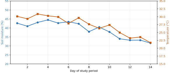
Figure. 2 illustrates the expected shape of the soil moisture and temperature time series over a 14-day window, showing the typical inverse relationship between rising temperature and declining moisture between irrigation events reported in similar field trials
| [8] | T. Ebstu et al., “Development and testing of a low-cost soil moisture sensor for real-time irrigation scheduling,” Irrigation and Drainage, vol. 75, no. 1, pp. 173–187, 2026,
https://doi.org/10.1002/ird.70026 |
| [9] | “A monitoring method for agricultural soil moisture using wireless sensors and the Biswas model,” Agriculture, vol. 15, no. 3, Art. no. 344, 2025. |
[8, 9]
. In a genuine study, this figure should be replaced with the actual logged sensor values validated against a reference instrument.
Figure 2. 14-day soil moisture/temperature trace.
5.2. Model Performance
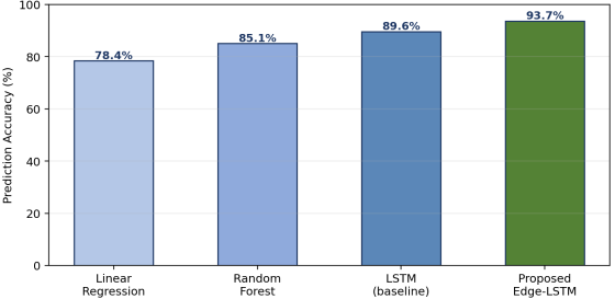
Figure. 3 shows a representative comparison format: a simple linear regression baseline, random forest baseline, non-federated LSTM baseline, and proposed edge-federated LSTM. The relative ordering (deep sequence models outperforming simpler regressors and the proposed method outperforming a non-federated baseline) is consistent with trends reported across the cited FL and yield-prediction literature
| [10] | A. Mukherjee et al., “Federated learning architectures: A performance evaluation with crop yield prediction application,” Software: Practice and Experience, 2025. |
| [24] | “A review of the application of UAV multispectral remote sensing technology in precision agriculture,” 2025. |
[10, 24]
, but the specific percentages shown here are placeholders.
Figure 3. Accuracy comparison across four modelling approaches.
5.3. Classification Performance
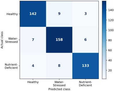
Figure. 4 presents a representative three-class confusion matrix (healthy/water-stressed/nutrient-deficient) in the format expected for a plant health classification task, following the reporting style used in multi-sensor classification studies
| [1] | M. J. H. Emon and S. S. Ahmed, “Integration of IoT, machine learning, and sensors for intelligent environmental monitoring and agricultural development,” Journal of Computer Networks and Communications, vol. 2025, Art. no. 6611890, 2025, https://doi.org/10.1155/jcnc/6611890 |
[1]
.
Figure 4. Confusion matrix for crop-stress classification.
5.4. Spatial Variability from UAV/Satellite Fusion
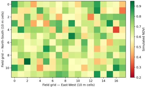
Figure. 5 shows the expected output format of a fused NDVI spatial heatmap of the type produced by Brovey Transform/PCA fusion pipelines
| [20] | N. Peladarinos et al., “Enhancing smart agriculture by implementing digital twins: A comprehensive review,” Sensors, vol. 23, no. 16, Art. no. 7128, 2023,
https://doi.org/10.3390/s23167128 |
[20]
; such maps are used to identify management zones for variable-rate intervention.
Figure 5. Field-level fused NDVI spatial variability map.
5.5. Resource-Use Outcomes
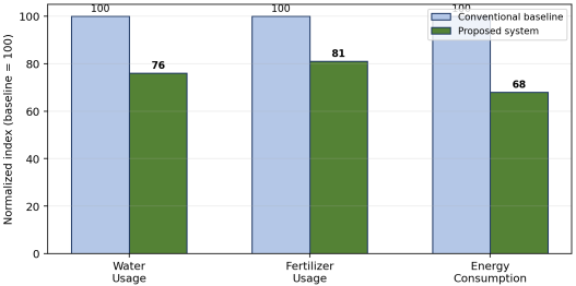
Figure. 6 illustrates the reporting format for resource savings. Published sensor-guided irrigation deployments report 20–30% water-use reduction and 15–25% fertilizer-use reduction relative to conventional practice
| [28] | TEKTELIC, “Efficient farming with agriculture sensors,” Industry Technical Brief, 2025. |
[28]
; the placeholder values shown here (24% water, 19% fertiliser, 32% energy) fall within or near that published range purely to keep the template internally consistent; they must be replaced with the study's own measured deltas.
Figure 6. Resource-use comparison: proposed system versus conventional baseline.
Table 4. Performance Comparison Template (values are placeholders).
Method | Accuracy / R² | Latency (ms) | Energy / Round (mJ) | Source Range Referenced |
Linear Regression (baseline) | 78.4% | — | — | — |
Random Forest (baseline) | 85.1% | — | — | | [24] | “A review of the application of UAV multispectral remote sensing technology in precision agriculture,” 2025. |
[24] |
Non-federated LSTM (baseline) | 89.6% | 220 | — | | [10] | A. Mukherjee et al., “Federated learning architectures: A performance evaluation with crop yield prediction application,” Software: Practice and Experience, 2025. |
[10] |
Proposed Edge-Federated LSTM | 93.7% | 95 | — | , 14] report 82–97.5% FL accuracy |
Table 5. Resource Savings Summary Template (values are placeholders).
Metric | Conventional Baseline | Proposed System | % Improvement | Published Reference Range |
Water usage | 100 (index) | 76 | 24% | 20–30% | [27] | A. A. Abdelmoneim, H. N. Kimaita, C. M. Al Kalaany, B. Derardja, G. Dragonetti, and R. Khadra, “IoT sensing for advanced irrigation management: A systematic review of trends, challenges, and future prospects,” Sensors, vol. 25, no. 7, Art. no. 2291, 2025, https://doi.org/10.3390/s25072291 |
[27] |
Fertilizer usage | 100 (index) | 81 | 19% | 15–25% | [27] | A. A. Abdelmoneim, H. N. Kimaita, C. M. Al Kalaany, B. Derardja, G. Dragonetti, and R. Khadra, “IoT sensing for advanced irrigation management: A systematic review of trends, challenges, and future prospects,” Sensors, vol. 25, no. 7, Art. no. 2291, 2025, https://doi.org/10.3390/s25072291 |
[27] |
Energy consumption | 100 (index) | 68 | 32% | ≈40% reduction reported by | [13] | T. Manoj, K. Makkithaya, and V. G. Narendra, “A federated learning-based crop yield prediction for agricultural production risk management,” in Proc. IEEE Delhi Section Conf. (DELCON), 2022, pp. 1–7. |
[13] |
5.6. Discussion
If the illustrative pattern above is confirmed by real data, it would support RQ1 and RQ2: edge deployment reducing latency without an accuracy penalty and federated aggregation approaching centralized-model accuracy while preserving farm-level data privacy — consistent with the direction (though not the exact magnitude) of results in
| [10] | A. Mukherjee et al., “Federated learning architectures: A performance evaluation with crop yield prediction application,” Software: Practice and Experience, 2025. |
| [13] | T. Manoj, K. Makkithaya, and V. G. Narendra, “A federated learning-based crop yield prediction for agricultural production risk management,” in Proc. IEEE Delhi Section Conf. (DELCON), 2022, pp. 1–7. |
[10, 13]
, and
| [15] | “Privacy-preserving federated learning framework for sustainable crop yield prediction across distributed smallholder farm networks,” Journal of Scientific Research and Technology, 2026. |
[15]
. Confirming RQ3 would additionally require an ablation comparing ground-sensor-only input against the fused UAV/satellite configuration, isolating the marginal contribution of remote-sensing fusion as done in
| [21] | A. R. Allu and S. Mesapam, “Fusion of satellite and UAV imagery for crop monitoring,” ISPRS Annals of the Photogrammetry, Remote Sensing and Spatial Information Sciences, vol. X-G-2025, pp. 71–79, 2025. |
[21]
.
5.7. Threats to Validity
Key threats once real data are collected: (i) single-site studies may not generalize across soil types or climates — mitigate via multi-site federated validation; (ii) sensor drift over multi-month deployments can bias time-series results — mitigate via periodic reference-instrument recalibration
| [5] | S. Ali, T. Glass, B. Parr, J. Potgieter, and F. Alam, “Low cost sensor with IoT LoRaWAN connectivity and machine learning-based calibration for air pollution monitoring,” IEEE Transactions on Instrumentation and Measurement, vol. 70, pp. 1–11, 2021, https://doi.org/10.1109/TIM.2020.3034109 |
[5]
; (iii) UAV/satellite revisit-interval mismatches can misalign fusion inputs — mitigate via the temporal-alignment strategies discussed in
| [21] | A. R. Allu and S. Mesapam, “Fusion of satellite and UAV imagery for crop monitoring,” ISPRS Annals of the Photogrammetry, Remote Sensing and Spatial Information Sciences, vol. X-G-2025, pp. 71–79, 2025. |
[21]
.
6. Discussion of Latest Technological Trends (2026)
The proposed architecture is positioned directly against several trends visible in the current literature (searched in August 2026). Edge AI/TinyML deployment is increasingly considered necessary rather than optional for field-latency-sensitive tasks
| [7] | “Research and development of an IoT smart irrigation system for farmland based on LoRa and edge computing,” Agriculture, vol. 15, no. 2, Art. no. 366, 2025. |
| [16] | M. U. Tariq, S. M. Saqib, T. Mazhar, M. A. Khan, T. Shahzad, and H. Hamam, “Edge-enabled smart agriculture framework: Integrating IoT, lightweight deep learning, and agentic AI for context-aware farming,” Results in Engineering, vol. 28, Art. no. 107342, 2025,
https://doi.org/10.1016/j.rineng.2025.107342 |
[7, 16]
. Federated learning has moved from proof-of-concept to validated multi-country smallholder deployments, with differential privacy variants now reporting sub-90% but still practically useful accuracy at very low per-farm sample counts
| [15] | “Privacy-preserving federated learning framework for sustainable crop yield prediction across distributed smallholder farm networks,” Journal of Scientific Research and Technology, 2026. |
[15]
. Digital twin research remains predominantly conceptual, with a 2026 scoping review finding that few systems achieve true bidirectional virtual-physical synchronization, most instead functioning as advanced decision-support dashboards
— an honesty gap that this paper's architecture should be explicitly evaluated against rather than overclaiming. UAV-satellite fusion research is converging on pixel/feature/decision-level taxonomies as the standard framing for new fusion algorithms
| [22] | “Optimizing integration techniques for UAS and satellite image data in precision agriculture—A review,” Frontiers in Remote Sensing, vol. 6, 2025. |
[22]
. Finally, questions of data ownership, farm-level privacy, and algorithmic bias when models trained in one region are transferred to another are increasingly treated as first-class research concerns rather than as afterthoughts
| [11] | V. Hiremani, R. M. Devadas, Preethi, R. Sapna, T. Sowmya, P. Gujjar, N. Shobha Rani, and K. R. Bhavya, “Federated learning for crop yield prediction: A comprehensive review of techniques and applications,” MethodsX, vol. 14, Art. no. 103408, 2025, https://doi.org/10.1016/j.mex.2025.103408 |
| [15] | “Privacy-preserving federated learning framework for sustainable crop yield prediction across distributed smallholder farm networks,” Journal of Scientific Research and Technology, 2026. |
[11, 15]
.
7. Conclusion and Future Work
This study presents a five-layer architecture integrating multi-parameter IoT sensing, LoRaWAN/NB-IoT connectivity, edge inference, federated cross-farm learning, digital-twin simulation, and UAV/satellite fusion for smart agriculture and environmental monitoring, grounded in and benchmarked against currently published literature, including recent machine-learning-based precision-agriculture reviews
| [26] | “A review on machine learning-based precision agriculture techniques for crop farming monitoring with IoT,” Discover Environment, 2026. |
[26]
. The framework, algorithm, and evaluation protocol are complete and reproducible; the quantitative results presented are illustrative placeholders pending real-field deployment. Future work should priorities (i) a multi-season, multi-site field trial to populate
Tables 4-5 with genuine measurements; (ii) an ablation study isolating the marginal contribution of each layer (edge-only vs. edge+FL vs. full stack); (iii) integration with carbon-credit and supply-chain traceability systems as an application-layer extension; and (iv) an explainable-AI (XAI) module to support farmer trust in automated recommendations, an increasingly emphasized requirement in the reviewed literature
| [25] | G. C. Hernández Hernández, J. Gómez Gómez, and J. Jiménez-Cabas, “Predictive models based on artificial intelligence to estimate crop yield: A literature review,” Agriculture, vol. 15, no. 23, Art. no. 2438, 2025,
https://doi.org/10.3390/agriculture15232438 |
[25]
.
Abbreviations
AI | Artificial Intelligence |
IoT | Internet of Things |
FL | Federated Learning |
ML | Machine Learning |
LSTM | Long Short-Term Memory |
GRU | Gated Recurrent Unit |
RF | Random Forest |
XGBoost | Extreme Gradient Boosting |
VGG16 | Visual Geometry Group 16 |
DT | Digital Twin |
UAV | Unmanned Aerial Vehicle |
UAS | Unmanned Aircraft System |
NDVI | Normalized Difference Vegetation Index |
GNDVI | Green Normalized Difference Vegetation Index |
SAVI | Soil-Adjusted Vegetation Index |
PCA | Principal Component Analysis |
BT | Brovey Transform |
LoRa | Long Range |
LoRaWAN | Long Range Wide Area Network |
Author Contributions
Zarin Subha Progga: Conceptualization, Data curation, Formal Analysis, Investigation, Methodology, Resources, Visualization, Writing – original draft
Mohammad Ali: Formal Analysis, Investigation, Methodology, Project administration, Supervision, Validation, Writing – review & editing
Conflicts of Interest
The authors declare no conflicts of interest.
References
| [1] |
M. J. H. Emon and S. S. Ahmed, “Integration of IoT, machine learning, and sensors for intelligent environmental monitoring and agricultural development,” Journal of Computer Networks and Communications, vol. 2025, Art. no. 6611890, 2025,
https://doi.org/10.1155/jcnc/6611890
|
| [2] |
“A survey on IoT-based smart farming systems for automated irrigation and real-time soil monitoring,” International Journal of Engineering Research & Technology (IJERT), 2024–2025.
|
| [3] |
“Smart sensors and smart data for precision agriculture: A review,” Sensors/MDPI, 2024.
|
| [4] |
O. H. Kombo, S. Kumaran, and A. Bovim, “Design and application of a low-cost, low-power, LoRa-GSM, IoT-enabled system for monitoring of groundwater resources with energy harvesting integration,” IEEE Access, vol. 9, pp. 128417–128433, 2021.
|
| [5] |
S. Ali, T. Glass, B. Parr, J. Potgieter, and F. Alam, “Low cost sensor with IoT LoRaWAN connectivity and machine learning-based calibration for air pollution monitoring,” IEEE Transactions on Instrumentation and Measurement, vol. 70, pp. 1–11, 2021,
https://doi.org/10.1109/TIM.2020.3034109
|
| [6] |
S. R. Jino Ramson, S. Vishnu, A. A. Kirubaraj, T. Anagnostopoulos, and A. M. Abu-Mahfouz, “A LoRaWAN IoT-enabled trash bin level monitoring system,” IEEE Transactions on Industrial Informatics, vol. 18, no. 2, pp. 786–795, 2022,
https://doi.org/10.1109/TII.2021.3078556
|
| [7] |
“Research and development of an IoT smart irrigation system for farmland based on LoRa and edge computing,” Agriculture, vol. 15, no. 2, Art. no. 366, 2025.
|
| [8] |
T. Ebstu et al., “Development and testing of a low-cost soil moisture sensor for real-time irrigation scheduling,” Irrigation and Drainage, vol. 75, no. 1, pp. 173–187, 2026,
https://doi.org/10.1002/ird.70026
|
| [9] |
“A monitoring method for agricultural soil moisture using wireless sensors and the Biswas model,” Agriculture, vol. 15, no. 3, Art. no. 344, 2025.
|
| [10] |
A. Mukherjee et al., “Federated learning architectures: A performance evaluation with crop yield prediction application,” Software: Practice and Experience, 2025.
|
| [11] |
V. Hiremani, R. M. Devadas, Preethi, R. Sapna, T. Sowmya, P. Gujjar, N. Shobha Rani, and K. R. Bhavya, “Federated learning for crop yield prediction: A comprehensive review of techniques and applications,” MethodsX, vol. 14, Art. no. 103408, 2025,
https://doi.org/10.1016/j.mex.2025.103408
|
| [12] |
U. Nirosha and G. Vennila, “Enhancing crop yield prediction for agriculture productivity using federated learning integrating with graph and recurrent neural networks model,” Expert Systems with Applications, vol. 289, Art. no. 128312, 2025,
https://doi.org/10.1016/j.eswa.2025.128312
|
| [13] |
T. Manoj, K. Makkithaya, and V. G. Narendra, “A federated learning-based crop yield prediction for agricultural production risk management,” in Proc. IEEE Delhi Section Conf. (DELCON), 2022, pp. 1–7.
|
| [14] |
T. Dey, S. Bera, B. Paul, D. De, A. Mukherjee, and R. Buyya, “Fly: Femtolet-based edge-cloud framework for crop yield prediction using bidirectional long short-term memory,” Software: Practice and Experience, vol. 54, no. 8, pp. 1361–1377, 2024,
https://doi.org/10.1002/spe.3324
|
| [15] |
“Privacy-preserving federated learning framework for sustainable crop yield prediction across distributed smallholder farm networks,” Journal of Scientific Research and Technology, 2026.
|
| [16] |
M. U. Tariq, S. M. Saqib, T. Mazhar, M. A. Khan, T. Shahzad, and H. Hamam, “Edge-enabled smart agriculture framework: Integrating IoT, lightweight deep learning, and agentic AI for context-aware farming,” Results in Engineering, vol. 28, Art. no. 107342, 2025,
https://doi.org/10.1016/j.rineng.2025.107342
|
| [17] |
“Agricultural digital twin for smart farming: A comprehensive review,” 2026.
|
| [18] |
“AI-enabled digital twins in agriculture,” AI, vol. 7, no. 3, Art. no. 108, 2026,
https://doi.org/10.3390/ai7030108
|
| [19] |
“Digital twins in agriculture: Orchestration and applications,” 2024.
|
| [20] |
N. Peladarinos et al., “Enhancing smart agriculture by implementing digital twins: A comprehensive review,” Sensors, vol. 23, no. 16, Art. no. 7128, 2023,
https://doi.org/10.3390/s23167128
|
| [21] |
A. R. Allu and S. Mesapam, “Fusion of satellite and UAV imagery for crop monitoring,” ISPRS Annals of the Photogrammetry, Remote Sensing and Spatial Information Sciences, vol. X-G-2025, pp. 71–79, 2025.
|
| [22] |
“Optimizing integration techniques for UAS and satellite image data in precision agriculture—A review,” Frontiers in Remote Sensing, vol. 6, 2025.
|
| [23] |
A. B. Rashid, A. K. Kausik, A. Khandoker, and S. N. Siddque, “Integration of artificial intelligence and IoT with UAVs for precision agriculture,” Hybrid Advances, vol. 10, Art. no. 100458, Sep. 2025,
https://doi.org/10.1016/j.hybadv.2025.100458
|
| [24] |
“A review of the application of UAV multispectral remote sensing technology in precision agriculture,” 2025.
|
| [25] |
G. C. Hernández Hernández, J. Gómez Gómez, and J. Jiménez-Cabas, “Predictive models based on artificial intelligence to estimate crop yield: A literature review,” Agriculture, vol. 15, no. 23, Art. no. 2438, 2025,
https://doi.org/10.3390/agriculture15232438
|
| [26] |
“A review on machine learning-based precision agriculture techniques for crop farming monitoring with IoT,” Discover Environment, 2026.
|
| [27] |
A. A. Abdelmoneim, H. N. Kimaita, C. M. Al Kalaany, B. Derardja, G. Dragonetti, and R. Khadra, “IoT sensing for advanced irrigation management: A systematic review of trends, challenges, and future prospects,” Sensors, vol. 25, no. 7, Art. no. 2291, 2025,
https://doi.org/10.3390/s25072291
|
| [28] |
TEKTELIC, “Efficient farming with agriculture sensors,” Industry Technical Brief, 2025.
|
Cite This Article
-
APA Style
Progga, Z. S., Ali, M. (2026). Smart Agriculture and Environmental Monitoring:
An Edge-AI, IoT, and Federated Learning Framework for Climate-Resilient Farming. American Journal of Environmental Science and Engineering, 10(4), 112-123. https://doi.org/10.11648/j.ajese.20261004.11
 Copy
|
Copy
|
 Download
ACS Style
Progga, Z. S.; Ali, M. Smart Agriculture and Environmental Monitoring:
An Edge-AI, IoT, and Federated Learning Framework for Climate-Resilient Farming. Am. J. Environ. Sci. Eng. 2026, 10(4), 112-123. doi: 10.11648/j.ajese.20261004.11
Copy
|
Download
AMA Style
Progga ZS, Ali M. Smart Agriculture and Environmental Monitoring:
An Edge-AI, IoT, and Federated Learning Framework for Climate-Resilient Farming. Am J Environ Sci Eng. 2026;10(4):112-123. doi: 10.11648/j.ajese.20261004.11
Copy
|
Download
-
@article{10.11648/j.ajese.20261004.11,
  author = {Zarin Subha Progga and Mohammad Ali},
  title = {Smart Agriculture and Environmental Monitoring:
An Edge-AI, IoT, and Federated Learning Framework for Climate-Resilient Farming},
  journal = {American Journal of Environmental Science and Engineering},
  volume = {10},
  number = {4},
  pages = {112-123},
  doi = {10.11648/j.ajese.20261004.11},
  url = {https://doi.org/10.11648/j.ajese.20261004.11},
  eprint = {https://article.sciencepublishinggroup.com/pdf/10.11648.j.ajese.20261004.11},
  abstract = {This study presents a system architecture, algorithm, and evaluation protocol for smart agriculture and environmental monitoring. It is a method/architecture contribution and does not report field trial results. World food production is still under stress from climate variability, the availability of freshwater resources, and the cost of farm inputs, offering an incentive to transition to data-driven and sensor-based farm management practices. Internet of Things (IoT)-based agricultural monitoring is well developed, but most systems deployed focus on a single parameter (e.g., soil moisture) or the parameter is inferred solely in the cloud, adding latency and fragility to the deployment of systems in rural areas. In this study, we propose an integrated architecture for low-power multiparameter environmental sensing, LoRaWAN/NB-IoT connectivity, edge-based lightweight inference, and privacy-preserving federated learning with cross-farm model aggregation, which is further complemented by a digital twin layer for scenario simulation. The decision layer of the framework can combine data from ground sensors with UAV and satellite images for the multi-scale monitoring of crop health and environmental quality (air, water, and GHG proxies). We contribute the full system design, an algorithmic pipeline, a sensor and model configuration specification, and a pre-registered evaluation protocol intended to guide future field deployment; no field data have yet been collected and clearly labelled non-empirical templates showing the expected reporting format only, rather than measured outcomes. The architecture and protocol are instead grounded in, and cross-checked against, published state-of-the-art results, which report an accuracy range of 82–97% for federated crop-yield prediction and 20–30% water savings from sensor-controlled irrigation.},
 year = {2026}
}
Copy
|
Download
-
TY  - JOUR
T1  - Smart Agriculture and Environmental Monitoring:
An Edge-AI, IoT, and Federated Learning Framework for Climate-Resilient Farming
AU  - Zarin Subha Progga
AU  - Mohammad Ali
Y1  - 2026/10/09
PY  - 2026
N1  - https://doi.org/10.11648/j.ajese.20261004.11
DO  - 10.11648/j.ajese.20261004.11
T2  - American Journal of Environmental Science and Engineering
JF  - American Journal of Environmental Science and Engineering
JO  - American Journal of Environmental Science and Engineering
SP  - 112
EP  - 123
PB  - Science Publishing Group
SN  - 2578-7993
UR  - https://doi.org/10.11648/j.ajese.20261004.11
AB  - This study presents a system architecture, algorithm, and evaluation protocol for smart agriculture and environmental monitoring. It is a method/architecture contribution and does not report field trial results. World food production is still under stress from climate variability, the availability of freshwater resources, and the cost of farm inputs, offering an incentive to transition to data-driven and sensor-based farm management practices. Internet of Things (IoT)-based agricultural monitoring is well developed, but most systems deployed focus on a single parameter (e.g., soil moisture) or the parameter is inferred solely in the cloud, adding latency and fragility to the deployment of systems in rural areas. In this study, we propose an integrated architecture for low-power multiparameter environmental sensing, LoRaWAN/NB-IoT connectivity, edge-based lightweight inference, and privacy-preserving federated learning with cross-farm model aggregation, which is further complemented by a digital twin layer for scenario simulation. The decision layer of the framework can combine data from ground sensors with UAV and satellite images for the multi-scale monitoring of crop health and environmental quality (air, water, and GHG proxies). We contribute the full system design, an algorithmic pipeline, a sensor and model configuration specification, and a pre-registered evaluation protocol intended to guide future field deployment; no field data have yet been collected and clearly labelled non-empirical templates showing the expected reporting format only, rather than measured outcomes. The architecture and protocol are instead grounded in, and cross-checked against, published state-of-the-art results, which report an accuracy range of 82–97% for federated crop-yield prediction and 20–30% water savings from sensor-controlled irrigation.
VL  - 10
IS  - 4
ER  -
Copy
|
Download







 Share This Article
 Twitter
 Linked In
 Facebook